You are here: Home > Network List > TA - USArray Transportable Network (new EarthScope stations) Stations List
> Station N13A Wendover, West Wendover, NV, USA > Earthquake Result Viewer
N13A Wendover, West Wendover, NV, USA - Earthquake Result Viewer
| Earthquake location: |
Vanuatu Islands |
| Earthquake latitude/longitude: |
-15.8/167.8 |
| Earthquake time(UTC): |
2006/08/07 (219) 22:18:54 GMT |
| Earthquake Depth: |
141 km |
| Earthquake Magnitude: |
6.0 MB, 6.8 MW, 6.8 MW |
| Earthquake Catalog/Contributor: |
WHDF/NEIC |
|
| Network: |
TA USArray Transportable Network (new EarthScope stations) |
| Station: |
N13A Wendover, West Wendover, NV, USA |
| Lat/Lon: |
40.86 N/114.20 W |
| Elevation: |
1385 m |
|
| Distance: |
91.4 deg |
| Az: |
47.916 deg |
| Baz: |
250.395 deg |
| Ray Param: |
0.04155575 |
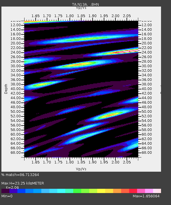
| Estimated Moho Depth: |
23.25 km |
| Estimated Crust Vp/Vs: |
2.06 |
| Assumed Crust Vp: |
6.276 km/s |
| Estimated Crust Vs: |
3.047 km/s |
| Estimated Crust Poisson's Ratio: |
0.35 |
|
| Radial Match: |
86.713264 % |
| Radial Bump: |
400 |
| Transverse Match: |
81.71787 % |
| Transverse Bump: |
400 |
| SOD ConfigId: |
2665 |
| Insert Time: |
2010-03-07 04:47:31.582 +0000 |
| GWidth: |
2.5 |
| Max Bumps: |
400 |
| Tol: |
0.001 |
|
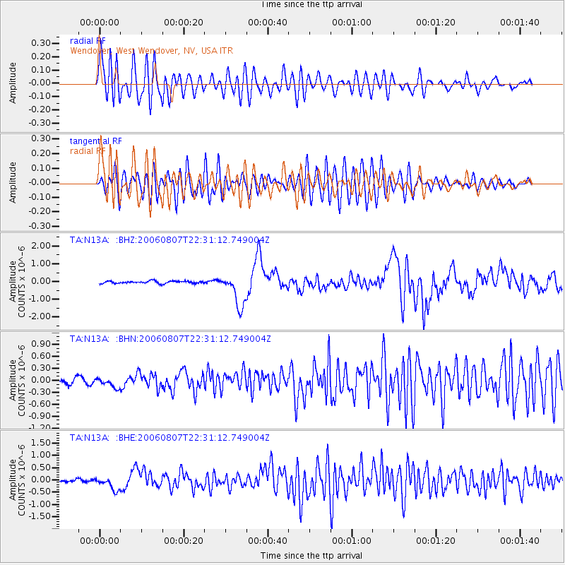
Signal To Noise
| Channel | StoN | STA | LTA |
| TA:N13A: :BHN:20060807T22:31:12.749004Z | 1.6977761 | 1.1892653E-7 | 7.004842E-8 |
| TA:N13A: :BHE:20060807T22:31:12.749004Z | 3.8418038 | 2.619176E-7 | 6.817568E-8 |
| TA:N13A: :BHZ:20060807T22:31:12.749004Z | 14.373735 | 9.83668E-7 | 6.84351E-8 |
| Arrivals |
| Ps | 4.0 SECOND |
| PpPs | 11 SECOND |
| PsPs/PpSs | 15 SECOND |


