You are here: Home > Network List > G - GEOSCOPE Stations List
> Station PPTF Pamatai - Papeete - Tahiti island - French Polynesia, France > Earthquake Result Viewer
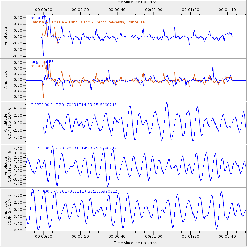
PPTF Pamatai - Papeete - Tahiti island - French Polynesia, France - Earthquake Result Viewer
*The percent match for this event was below the threshold and hence no stack was calculated.
| Earthquake location: |
Near Coast Of Ecuador |
| Earthquake latitude/longitude: |
0.7/-79.7 |
| Earthquake time(UTC): |
2017/01/31 (031) 14:22:40 GMT |
| Earthquake Depth: |
21 km |
| Earthquake Magnitude: |
5.5 Mww |
| Earthquake Catalog/Contributor: |
NEIC PDE/us |
|
| Network: |
G GEOSCOPE |
| Station: |
PPTF Pamatai - Papeete - Tahiti island - French Polynesia, France |
| Lat/Lon: |
17.59 S/149.57 W |
| Elevation: |
705 m |
|
| Distance: |
71.1 deg |
| Az: |
251.235 deg |
| Baz: |
83.03 deg |
| Ray Param: |
$rayparam |
*The percent match for this event was below the threshold and hence was not used in the summary stack. |
|
| Radial Match: |
67.63606 % |
| Radial Bump: |
400 |
| Transverse Match: |
49.213562 % |
| Transverse Bump: |
306 |
| SOD ConfigId: |
1943534 |
| Insert Time: |
2017-02-14 14:27:09.532 +0000 |
| GWidth: |
2.5 |
| Max Bumps: |
400 |
| Tol: |
0.001 |
|
Signal To Noise
| Channel | StoN | STA | LTA |
| G:PPTF:00:BHZ:20170131T14:33:25.699021Z | 2.4511757 | 2.3322184E-6 | 9.514693E-7 |
| G:PPTF:00:BHN:20170131T14:33:25.699021Z | 1.4717988 | 3.7121406E-6 | 2.5221793E-6 |
| G:PPTF:00:BHE:20170131T14:33:25.699021Z | 1.342381 | 1.674197E-6 | 1.2471846E-6 |
| Arrivals |
| Ps | |
| PpPs | |
| PsPs/PpSs | |


