You are here: Home > Network List > TA - USArray Transportable Network (new EarthScope stations) Stations List
> Station N13A Wendover, West Wendover, NV, USA > Earthquake Result Viewer
N13A Wendover, West Wendover, NV, USA - Earthquake Result Viewer
| Earthquake location: |
Rat Islands, Aleutian Islands |
| Earthquake latitude/longitude: |
52.2/176.2 |
| Earthquake time(UTC): |
2006/06/27 (178) 02:39:35 GMT |
| Earthquake Depth: |
34 km |
| Earthquake Magnitude: |
5.6 MB, 6.0 MS, 6.2 MW, 6.2 MW |
| Earthquake Catalog/Contributor: |
WHDF/NEIC |
|
| Network: |
TA USArray Transportable Network (new EarthScope stations) |
| Station: |
N13A Wendover, West Wendover, NV, USA |
| Lat/Lon: |
40.86 N/114.20 W |
| Elevation: |
1385 m |
|
| Distance: |
47.4 deg |
| Az: |
74.833 deg |
| Baz: |
308.459 deg |
| Ray Param: |
0.069914795 |
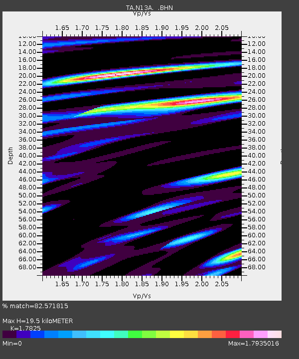
| Estimated Moho Depth: |
19.5 km |
| Estimated Crust Vp/Vs: |
1.78 |
| Assumed Crust Vp: |
6.276 km/s |
| Estimated Crust Vs: |
3.521 km/s |
| Estimated Crust Poisson's Ratio: |
0.27 |
|
| Radial Match: |
82.571815 % |
| Radial Bump: |
400 |
| Transverse Match: |
75.52976 % |
| Transverse Bump: |
400 |
| SOD ConfigId: |
2665 |
| Insert Time: |
2010-03-07 04:47:38.363 +0000 |
| GWidth: |
2.5 |
| Max Bumps: |
400 |
| Tol: |
0.001 |
|
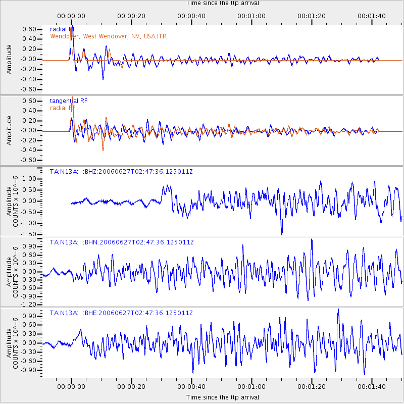
Signal To Noise
| Channel | StoN | STA | LTA |
| TA:N13A: :BHN:20060627T02:47:36.125011Z | 2.5018675 | 1.9881695E-7 | 7.946741E-8 |
| TA:N13A: :BHE:20060627T02:47:36.125011Z | 3.471931 | 2.1588497E-7 | 6.2180085E-8 |
| TA:N13A: :BHZ:20060627T02:47:36.125011Z | 6.526065 | 4.423228E-7 | 6.7777876E-8 |
| Arrivals |
| Ps | 2.6 SECOND |
| PpPs | 8.2 SECOND |
| PsPs/PpSs | 11 SECOND |


