You are here: Home > Network List > TA - USArray Transportable Network (new EarthScope stations) Stations List
> Station N13A Wendover, West Wendover, NV, USA > Earthquake Result Viewer
N13A Wendover, West Wendover, NV, USA - Earthquake Result Viewer
| Earthquake location: |
Southeast Of Loyalty Islands |
| Earthquake latitude/longitude: |
-21.5/170.9 |
| Earthquake time(UTC): |
2007/07/27 (208) 14:46:26 GMT |
| Earthquake Depth: |
10 km |
| Earthquake Magnitude: |
6.0 MB, 6.0 MS, 6.1 MW, 6.1 MW |
| Earthquake Catalog/Contributor: |
WHDF/NEIC |
|
| Network: |
TA USArray Transportable Network (new EarthScope stations) |
| Station: |
N13A Wendover, West Wendover, NV, USA |
| Lat/Lon: |
40.86 N/114.20 W |
| Elevation: |
1385 m |
|
| Distance: |
93.0 deg |
| Az: |
47.155 deg |
| Baz: |
244.211 deg |
| Ray Param: |
0.041346345 |
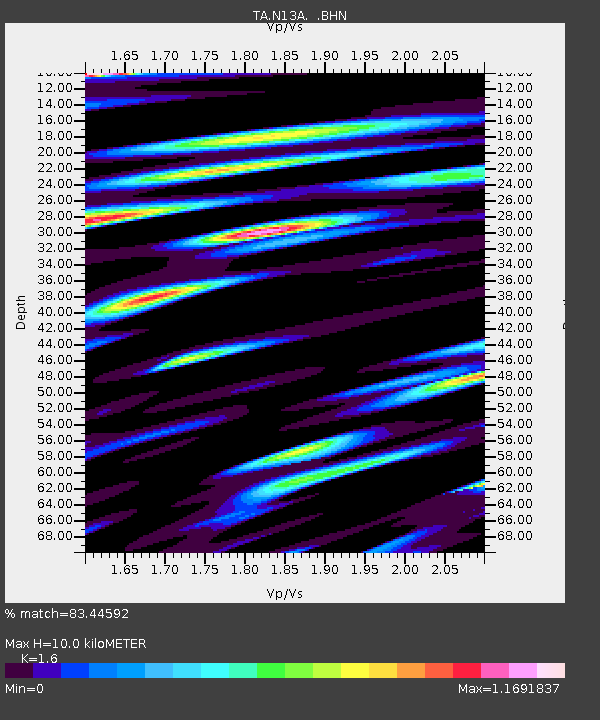
| Estimated Moho Depth: |
10.0 km |
| Estimated Crust Vp/Vs: |
1.60 |
| Assumed Crust Vp: |
6.276 km/s |
| Estimated Crust Vs: |
3.922 km/s |
| Estimated Crust Poisson's Ratio: |
0.18 |
|
| Radial Match: |
83.44592 % |
| Radial Bump: |
400 |
| Transverse Match: |
84.83182 % |
| Transverse Bump: |
400 |
| SOD ConfigId: |
2564 |
| Insert Time: |
2010-03-07 04:47:51.390 +0000 |
| GWidth: |
2.5 |
| Max Bumps: |
400 |
| Tol: |
0.001 |
|
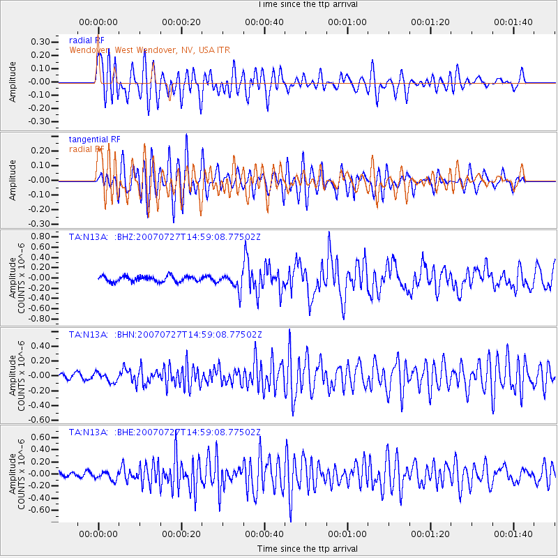
Signal To Noise
| Channel | StoN | STA | LTA |
| TA:N13A: :BHN:20070727T14:59:08.77502Z | 1.4703414 | 6.5048596E-8 | 4.4240473E-8 |
| TA:N13A: :BHE:20070727T14:59:08.77502Z | 1.4212176 | 6.750376E-8 | 4.7497135E-8 |
| TA:N13A: :BHZ:20070727T14:59:08.77502Z | 3.0102072 | 1.6400003E-7 | 5.4481305E-8 |
| Arrivals |
| Ps | 1.0 SECOND |
| PpPs | 4.1 SECOND |
| PsPs/PpSs | 5.0 SECOND |


