You are here: Home > Network List > TA - USArray Transportable Network (new EarthScope stations) Stations List
> Station N13A Wendover, West Wendover, NV, USA > Earthquake Result Viewer
N13A Wendover, West Wendover, NV, USA - Earthquake Result Viewer
| Earthquake location: |
Andreanof Islands, Aleutian Is. |
| Earthquake latitude/longitude: |
51.9/-179.4 |
| Earthquake time(UTC): |
2008/04/15 (106) 22:59:51 GMT |
| Earthquake Depth: |
10 km |
| Earthquake Magnitude: |
6.1 MB, 6.4 MS, 6.4 MW, 6.4 MW |
| Earthquake Catalog/Contributor: |
WHDF/NEIC |
|
| Network: |
TA USArray Transportable Network (new EarthScope stations) |
| Station: |
N13A Wendover, West Wendover, NV, USA |
| Lat/Lon: |
40.86 N/114.20 W |
| Elevation: |
1385 m |
|
| Distance: |
44.9 deg |
| Az: |
77.377 deg |
| Baz: |
307.069 deg |
| Ray Param: |
0.07165725 |
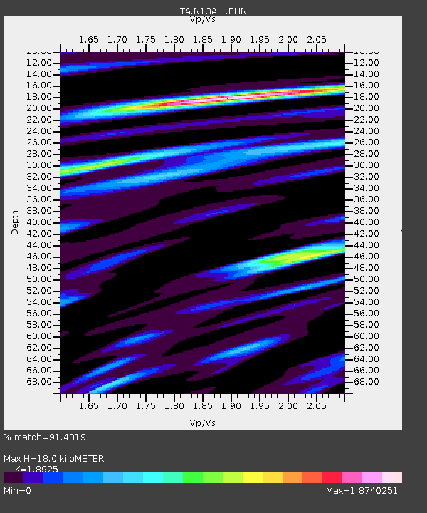
| Estimated Moho Depth: |
18.0 km |
| Estimated Crust Vp/Vs: |
1.89 |
| Assumed Crust Vp: |
6.276 km/s |
| Estimated Crust Vs: |
3.316 km/s |
| Estimated Crust Poisson's Ratio: |
0.31 |
|
| Radial Match: |
91.4319 % |
| Radial Bump: |
400 |
| Transverse Match: |
86.58556 % |
| Transverse Bump: |
400 |
| SOD ConfigId: |
2504 |
| Insert Time: |
2010-03-07 04:48:11.728 +0000 |
| GWidth: |
2.5 |
| Max Bumps: |
400 |
| Tol: |
0.001 |
|

Signal To Noise
| Channel | StoN | STA | LTA |
| TA:N13A: :BHN:20080415T23:07:34.800012Z | 6.2950644 | 1.8537436E-6 | 2.944757E-7 |
| TA:N13A: :BHE:20080415T23:07:34.800012Z | 4.500528 | 1.0783182E-6 | 2.3959817E-7 |
| TA:N13A: :BHZ:20080415T23:07:34.800012Z | 5.445523 | 6.466438E-7 | 1.1874779E-7 |
| Arrivals |
| Ps | 2.7 SECOND |
| PpPs | 7.8 SECOND |
| PsPs/PpSs | 11 SECOND |


