You are here: Home > Network List > TA - USArray Transportable Network (new EarthScope stations) Stations List
> Station N13A Wendover, West Wendover, NV, USA > Earthquake Result Viewer
N13A Wendover, West Wendover, NV, USA - Earthquake Result Viewer
| Earthquake location: |
Andreanof Islands, Aleutian Is. |
| Earthquake latitude/longitude: |
51.9/-179.2 |
| Earthquake time(UTC): |
2008/04/16 (107) 05:54:19 GMT |
| Earthquake Depth: |
13 km |
| Earthquake Magnitude: |
6.1 MB, 6.5 MS, 6.6 MW, 6.6 MW |
| Earthquake Catalog/Contributor: |
WHDF/NEIC |
|
| Network: |
TA USArray Transportable Network (new EarthScope stations) |
| Station: |
N13A Wendover, West Wendover, NV, USA |
| Lat/Lon: |
40.86 N/114.20 W |
| Elevation: |
1385 m |
|
| Distance: |
44.7 deg |
| Az: |
77.525 deg |
| Baz: |
307.065 deg |
| Ray Param: |
0.071724735 |
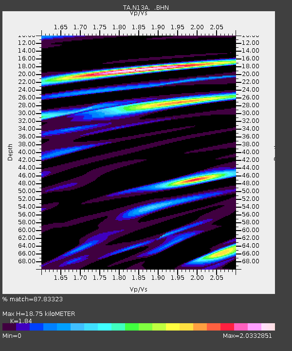
| Estimated Moho Depth: |
18.75 km |
| Estimated Crust Vp/Vs: |
1.84 |
| Assumed Crust Vp: |
6.276 km/s |
| Estimated Crust Vs: |
3.411 km/s |
| Estimated Crust Poisson's Ratio: |
0.29 |
|
| Radial Match: |
87.83323 % |
| Radial Bump: |
400 |
| Transverse Match: |
86.875336 % |
| Transverse Bump: |
400 |
| SOD ConfigId: |
2504 |
| Insert Time: |
2010-03-07 04:48:15.701 +0000 |
| GWidth: |
2.5 |
| Max Bumps: |
400 |
| Tol: |
0.001 |
|
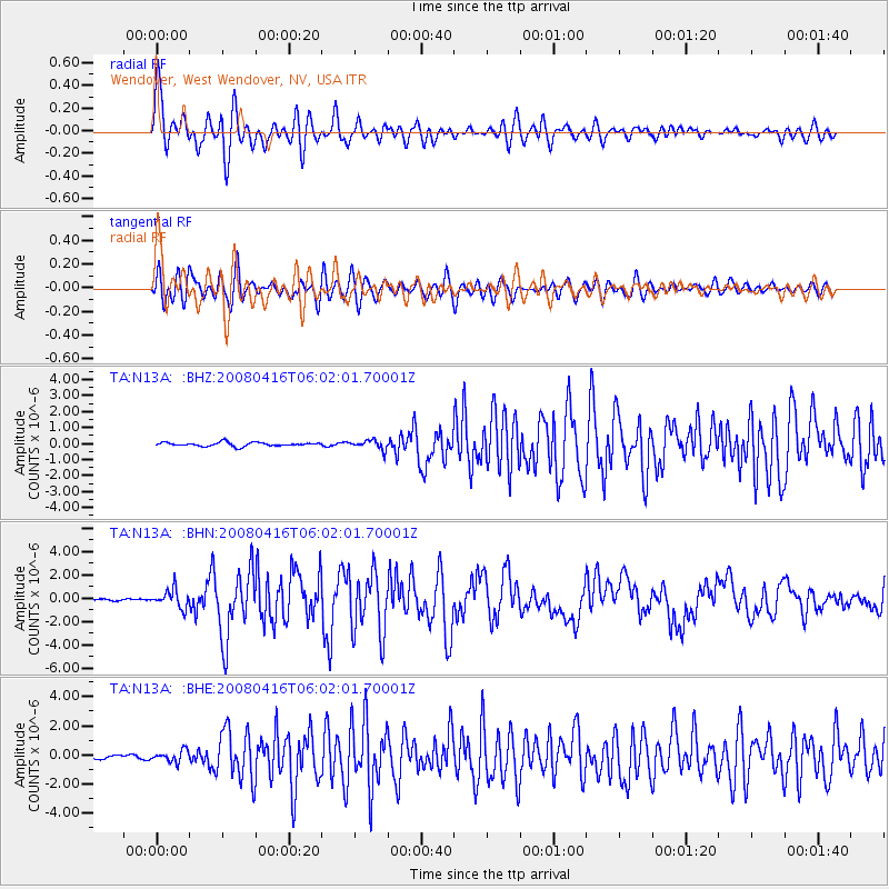
Signal To Noise
| Channel | StoN | STA | LTA |
| TA:N13A: :BHN:20080416T06:02:01.70001Z | 6.4703574 | 7.806511E-7 | 1.2065038E-7 |
| TA:N13A: :BHE:20080416T06:02:01.70001Z | 2.7839594 | 3.8220332E-7 | 1.3728767E-7 |
| TA:N13A: :BHZ:20080416T06:02:01.70001Z | 2.3599536 | 2.8738296E-7 | 1.2177483E-7 |
| Arrivals |
| Ps | 2.7 SECOND |
| PpPs | 8.0 SECOND |
| PsPs/PpSs | 11 SECOND |


