You are here: Home > Network List > TA - USArray Transportable Network (new EarthScope stations) Stations List
> Station N13A Wendover, West Wendover, NV, USA > Earthquake Result Viewer
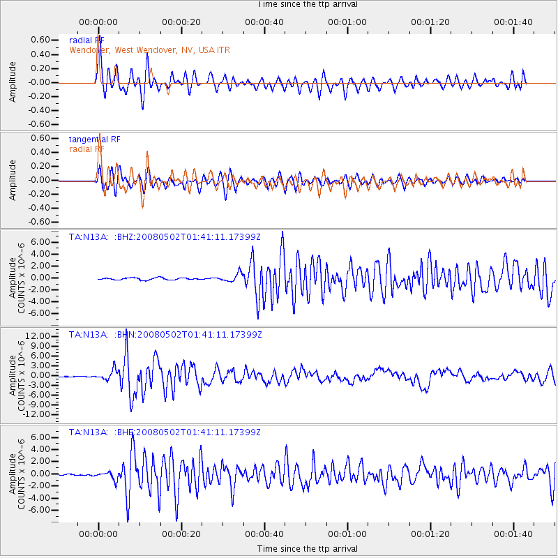
N13A Wendover, West Wendover, NV, USA - Earthquake Result Viewer

| Earthquake location: |
Andreanof Islands, Aleutian Is. |
| Earthquake latitude/longitude: |
51.9/-177.5 |
| Earthquake time(UTC): |
2008/05/02 (123) 01:33:37 GMT |
| Earthquake Depth: |
14 km |
| Earthquake Magnitude: |
6.3 MB, 6.8 MS, 6.6 MW, 6.6 MW |
| Earthquake Catalog/Contributor: |
WHDF/NEIC |
|
| Network: |
TA USArray Transportable Network (new EarthScope stations) |
| Station: |
N13A Wendover, West Wendover, NV, USA |
| Lat/Lon: |
40.86 N/114.20 W |
| Elevation: |
1385 m |
|
| Distance: |
43.7 deg |
| Az: |
78.58 deg |
| Baz: |
306.744 deg |
| Ray Param: |
0.07234051 |
| Estimated Moho Depth: |
19.5 km |
| Estimated Crust Vp/Vs: |
1.79 |
| Assumed Crust Vp: |
6.276 km/s |
| Estimated Crust Vs: |
3.516 km/s |
| Estimated Crust Poisson's Ratio: |
0.27 |
|
| Radial Match: |
87.85695 % |
| Radial Bump: |
400 |
| Transverse Match: |
83.89896 % |
| Transverse Bump: |
400 |
| SOD ConfigId: |
2504 |
| Insert Time: |
2010-03-07 04:48:17.665 +0000 |
| GWidth: |
2.5 |
| Max Bumps: |
400 |
| Tol: |
0.001 |
|
Signal To Noise
| Channel | StoN | STA | LTA |
| TA:N13A: :BHN:20080502T01:41:11.17399Z | 22.902004 | 1.5812484E-6 | 6.9044106E-8 |
| TA:N13A: :BHE:20080502T01:41:11.17399Z | 6.080115 | 6.7243207E-7 | 1.10595295E-7 |
| TA:N13A: :BHZ:20080502T01:41:11.17399Z | 4.1388955 | 7.2002587E-7 | 1.739657E-7 |
| Arrivals |
| Ps | 2.6 SECOND |
| PpPs | 8.1 SECOND |
| PsPs/PpSs | 11 SECOND |


