You are here: Home > Network List > TA - USArray Transportable Network (new EarthScope stations) Stations List
> Station N13A Wendover, West Wendover, NV, USA > Earthquake Result Viewer
N13A Wendover, West Wendover, NV, USA - Earthquake Result Viewer
| Earthquake location: |
Central Mid-Atlantic Ridge |
| Earthquake latitude/longitude: |
7.3/-34.9 |
| Earthquake time(UTC): |
2008/05/23 (144) 19:35:34 GMT |
| Earthquake Depth: |
9.0 km |
| Earthquake Magnitude: |
6.0 MB, 6.4 MS, 6.5 MW, 6.5 MW |
| Earthquake Catalog/Contributor: |
WHDF/NEIC |
|
| Network: |
TA USArray Transportable Network (new EarthScope stations) |
| Station: |
N13A Wendover, West Wendover, NV, USA |
| Lat/Lon: |
40.86 N/114.20 W |
| Elevation: |
1385 m |
|
| Distance: |
77.2 deg |
| Az: |
310.143 deg |
| Baz: |
91.411 deg |
| Ray Param: |
0.05050368 |
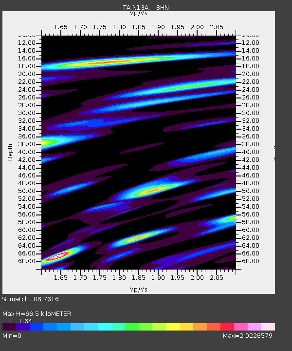
| Estimated Moho Depth: |
66.5 km |
| Estimated Crust Vp/Vs: |
1.64 |
| Assumed Crust Vp: |
6.276 km/s |
| Estimated Crust Vs: |
3.827 km/s |
| Estimated Crust Poisson's Ratio: |
0.20 |
|
| Radial Match: |
86.7616 % |
| Radial Bump: |
400 |
| Transverse Match: |
78.98829 % |
| Transverse Bump: |
400 |
| SOD ConfigId: |
2504 |
| Insert Time: |
2010-03-07 04:48:19.538 +0000 |
| GWidth: |
2.5 |
| Max Bumps: |
400 |
| Tol: |
0.001 |
|

Signal To Noise
| Channel | StoN | STA | LTA |
| TA:N13A: :BHN:20080523T19:46:57.57501Z | 2.6442897 | 6.889267E-7 | 2.6053374E-7 |
| TA:N13A: :BHE:20080523T19:46:57.57501Z | 1.2816262 | 5.162569E-7 | 4.028139E-7 |
| TA:N13A: :BHZ:20080523T19:46:57.57501Z | 2.0053117 | 3.8191945E-7 | 1.9045392E-7 |
| Arrivals |
| Ps | 7.0 SECOND |
| PpPs | 27 SECOND |
| PsPs/PpSs | 34 SECOND |


