You are here: Home > Network List > TA - USArray Transportable Network (new EarthScope stations) Stations List
> Station N13A Wendover, West Wendover, NV, USA > Earthquake Result Viewer
N13A Wendover, West Wendover, NV, USA - Earthquake Result Viewer
| Earthquake location: |
Solomon Islands |
| Earthquake latitude/longitude: |
-10.5/161.3 |
| Earthquake time(UTC): |
2008/06/03 (155) 16:20:50 GMT |
| Earthquake Depth: |
84 km |
| Earthquake Magnitude: |
6.2 MB, 6.2 MW, 6.2 MW |
| Earthquake Catalog/Contributor: |
WHDF/NEIC |
|
| Network: |
TA USArray Transportable Network (new EarthScope stations) |
| Station: |
N13A Wendover, West Wendover, NV, USA |
| Lat/Lon: |
40.86 N/114.20 W |
| Elevation: |
1385 m |
|
| Distance: |
92.7 deg |
| Az: |
49.104 deg |
| Baz: |
258.531 deg |
| Ray Param: |
0.04136598 |
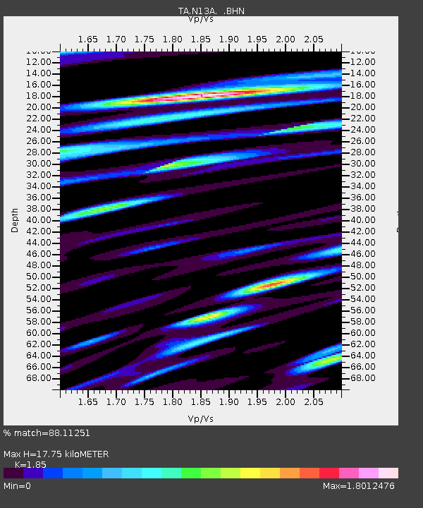
| Estimated Moho Depth: |
17.75 km |
| Estimated Crust Vp/Vs: |
1.85 |
| Assumed Crust Vp: |
6.276 km/s |
| Estimated Crust Vs: |
3.392 km/s |
| Estimated Crust Poisson's Ratio: |
0.29 |
|
| Radial Match: |
88.11251 % |
| Radial Bump: |
400 |
| Transverse Match: |
77.53011 % |
| Transverse Bump: |
400 |
| SOD ConfigId: |
2504 |
| Insert Time: |
2010-03-07 04:48:23.199 +0000 |
| GWidth: |
2.5 |
| Max Bumps: |
400 |
| Tol: |
0.001 |
|
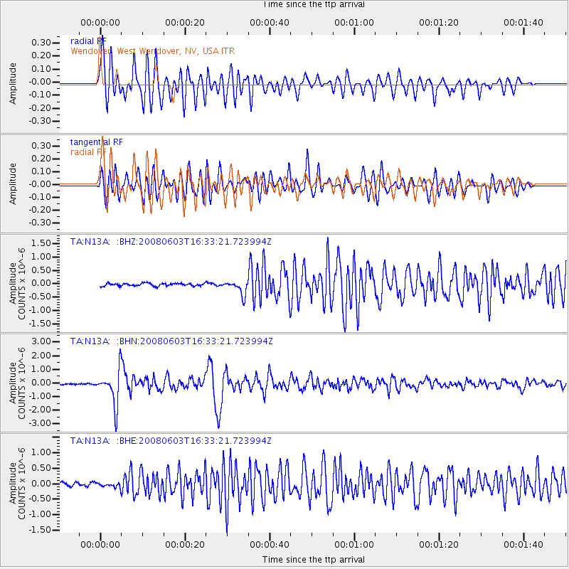
Signal To Noise
| Channel | StoN | STA | LTA |
| TA:N13A: :BHN:20080603T16:33:21.723994Z | 20.980913 | 1.317839E-6 | 6.2811324E-8 |
| TA:N13A: :BHE:20080603T16:33:21.723994Z | 1.2031856 | 7.368112E-8 | 6.1238374E-8 |
| TA:N13A: :BHZ:20080603T16:33:21.723994Z | 5.5879335 | 2.7027923E-7 | 4.836837E-8 |
| Arrivals |
| Ps | 2.4 SECOND |
| PpPs | 7.9 SECOND |
| PsPs/PpSs | 10 SECOND |


