You are here: Home > Network List > TA - USArray Transportable Network (new EarthScope stations) Stations List
> Station N13A Wendover, West Wendover, NV, USA > Earthquake Result Viewer
N13A Wendover, West Wendover, NV, USA - Earthquake Result Viewer
| Earthquake location: |
Tonga Islands |
| Earthquake latitude/longitude: |
-20.8/-173.3 |
| Earthquake time(UTC): |
2008/06/26 (178) 21:19:15 GMT |
| Earthquake Depth: |
38 km |
| Earthquake Magnitude: |
6.0 MB, 5.8 MS, 6.2 MW, 6.1 MW |
| Earthquake Catalog/Contributor: |
WHDF/NEIC |
|
| Network: |
TA USArray Transportable Network (new EarthScope stations) |
| Station: |
N13A Wendover, West Wendover, NV, USA |
| Lat/Lon: |
40.86 N/114.20 W |
| Elevation: |
1385 m |
|
| Distance: |
82.3 deg |
| Az: |
41.078 deg |
| Baz: |
234.16 deg |
| Ray Param: |
0.046944853 |
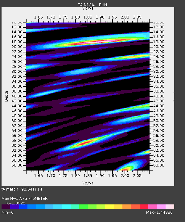
| Estimated Moho Depth: |
17.75 km |
| Estimated Crust Vp/Vs: |
1.89 |
| Assumed Crust Vp: |
6.276 km/s |
| Estimated Crust Vs: |
3.316 km/s |
| Estimated Crust Poisson's Ratio: |
0.31 |
|
| Radial Match: |
90.641914 % |
| Radial Bump: |
400 |
| Transverse Match: |
88.7737 % |
| Transverse Bump: |
400 |
| SOD ConfigId: |
2504 |
| Insert Time: |
2010-03-07 04:48:26.688 +0000 |
| GWidth: |
2.5 |
| Max Bumps: |
400 |
| Tol: |
0.001 |
|
Signal To Noise
| Channel | StoN | STA | LTA |
| TA:N13A: :BHN:20080626T21:31:01.97502Z | 35.865715 | 2.4119993E-6 | 6.725083E-8 |
| TA:N13A: :BHE:20080626T21:31:01.97502Z | 7.446213 | 5.2546795E-7 | 7.056848E-8 |
| TA:N13A: :BHZ:20080626T21:31:01.97502Z | 8.396626 | 6.56224E-7 | 7.81533E-8 |
| Arrivals |
| Ps | 2.6 SECOND |
| PpPs | 8.0 SECOND |
| PsPs/PpSs | 11 SECOND |


