You are here: Home > Network List > TS - TERRAscope (Southern California Seismic Network) Stations List
> Station NEE Needles, California, USA > Earthquake Result Viewer
NEE Needles, California, USA - Earthquake Result Viewer

| Earthquake location: |
Colombia |
| Earthquake latitude/longitude: |
4.2/-76.6 |
| Earthquake time(UTC): |
1995/02/08 (039) 18:40:25 GMT |
| Earthquake Depth: |
69 km |
| Earthquake Magnitude: |
6.3 MB, 6.4 UNKNOWN, 6.0 MD |
| Earthquake Catalog/Contributor: |
WHDF/NEIC |
|
| Network: |
TS TERRAscope (Southern California Seismic Network) |
| Station: |
NEE Needles, California, USA |
| Lat/Lon: |
34.82 N/114.60 W |
| Elevation: |
139 m |
|
| Distance: |
46.5 deg |
| Az: |
315.795 deg |
| Baz: |
122.299 deg |
| Ray Param: |
0.07038096 |
| Estimated Moho Depth: |
19.0 km |
| Estimated Crust Vp/Vs: |
2.10 |
| Assumed Crust Vp: |
6.276 km/s |
| Estimated Crust Vs: |
2.996 km/s |
| Estimated Crust Poisson's Ratio: |
0.35 |
|
| Radial Match: |
89.28111 % |
| Radial Bump: |
400 |
| Transverse Match: |
79.14972 % |
| Transverse Bump: |
400 |
| SOD ConfigId: |
6273 |
| Insert Time: |
2010-02-26 14:30:36.493 +0000 |
| GWidth: |
2.5 |
| Max Bumps: |
400 |
| Tol: |
0.001 |
|
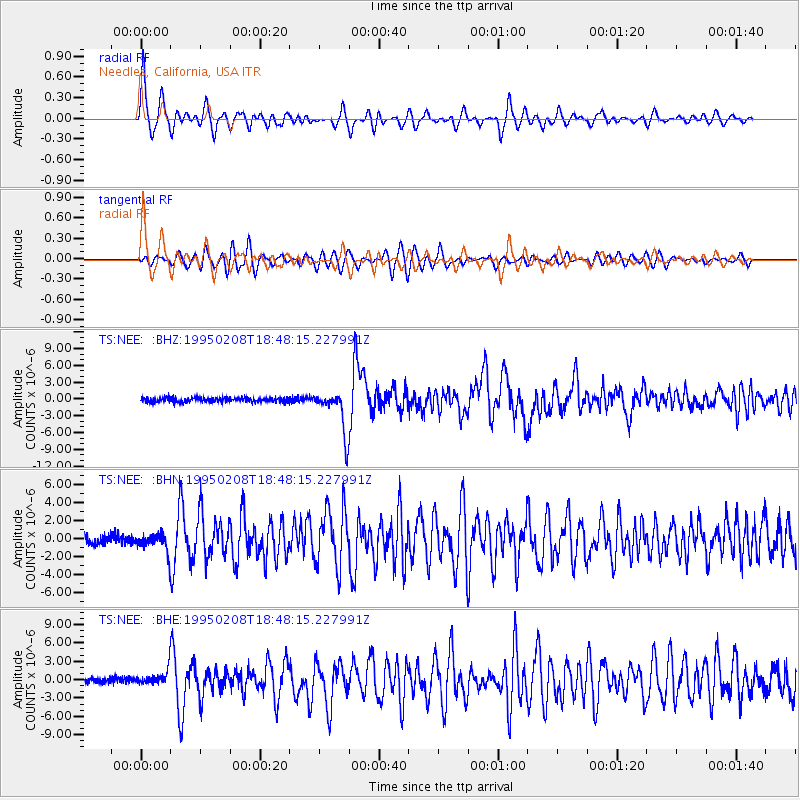
Signal To Noise
| Channel | StoN | STA | LTA |
| TS:NEE: :BHN:19950208T18:48:15.227991Z | 2.6831076 | 1.0991354E-6 | 4.0965017E-7 |
| TS:NEE: :BHE:19950208T18:48:15.227991Z | 3.6630516 | 1.3617125E-6 | 3.7174263E-7 |
| TS:NEE: :BHZ:19950208T18:48:15.227991Z | 9.534948 | 3.7674054E-6 | 3.9511545E-7 |
| Arrivals |
| Ps | 3.5 SECOND |
| PpPs | 8.9 SECOND |
| PsPs/PpSs | 12 SECOND |


