You are here: Home > Network List > AV - Alaska Volcano Observatory Stations List
> Station SPCR Ckakachatna River, Mount Spurr, Alaska > Earthquake Result Viewer
SPCR Ckakachatna River, Mount Spurr, Alaska - Earthquake Result Viewer
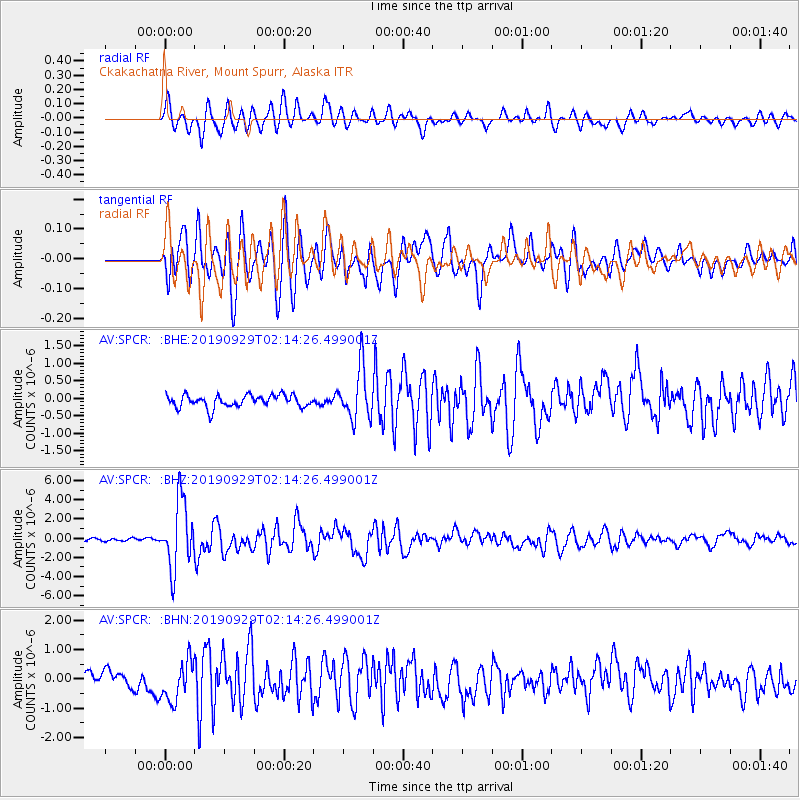
| Earthquake location: |
Mindanao, Philippines |
| Earthquake latitude/longitude: |
5.7/126.5 |
| Earthquake time(UTC): |
2019/09/29 (272) 02:02:52 GMT |
| Earthquake Depth: |
76 km |
| Earthquake Magnitude: |
6.2 Mww |
| Earthquake Catalog/Contributor: |
NEIC PDE/us |
|
| Network: |
AV Alaska Volcano Observatory |
| Station: |
SPCR Ckakachatna River, Mount Spurr, Alaska |
| Lat/Lon: |
61.20 N/152.21 W |
| Elevation: |
984 m |
|
| Distance: |
80.8 deg |
| Az: |
28.999 deg |
| Baz: |
265.068 deg |
| Ray Param: |
0.047859646 |
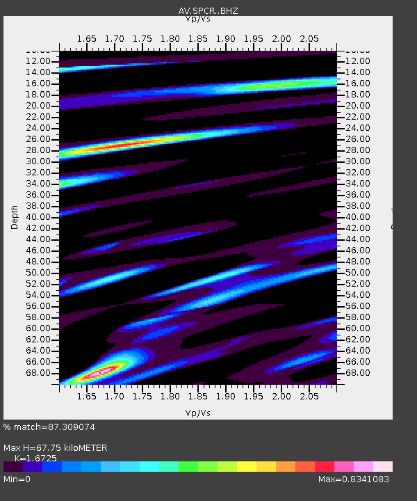
| Estimated Moho Depth: |
67.75 km |
| Estimated Crust Vp/Vs: |
1.67 |
| Assumed Crust Vp: |
6.566 km/s |
| Estimated Crust Vs: |
3.926 km/s |
| Estimated Crust Poisson's Ratio: |
0.22 |
|
| Radial Match: |
87.309074 % |
| Radial Bump: |
400 |
| Transverse Match: |
74.86758 % |
| Transverse Bump: |
400 |
| SOD ConfigId: |
19053131 |
| Insert Time: |
2019-10-13 02:08:01.685 +0000 |
| GWidth: |
2.5 |
| Max Bumps: |
400 |
| Tol: |
0.001 |
|
Signal To Noise
| Channel | StoN | STA | LTA |
| AV:SPCR: :BHZ:20190929T02:14:26.499001Z | 26.299103 | 3.4774184E-6 | 1.3222574E-7 |
| AV:SPCR: :BHN:20190929T02:14:26.499001Z | 2.4985046 | 6.779855E-7 | 2.7135653E-7 |
| AV:SPCR: :BHE:20190929T02:14:26.499001Z | 4.311611 | 7.396612E-7 | 1.7155098E-7 |
| Arrivals |
| Ps | 7.2 SECOND |
| PpPs | 27 SECOND |
| PsPs/PpSs | 34 SECOND |


