You are here: Home > Network List > TA - USArray Transportable Network (new EarthScope stations) Stations List
> Station N13A Wendover, West Wendover, NV, USA > Earthquake Result Viewer
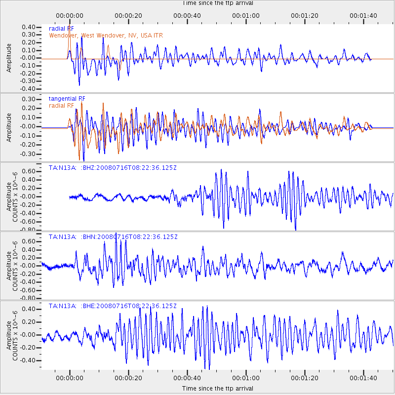
N13A Wendover, West Wendover, NV, USA - Earthquake Result Viewer
*The percent match for this event was below the threshold and hence no stack was calculated.
| Earthquake location: |
Samoa Islands Region |
| Earthquake latitude/longitude: |
-16.6/-173.0 |
| Earthquake time(UTC): |
2008/07/16 (198) 08:11:04 GMT |
| Earthquake Depth: |
10 km |
| Earthquake Magnitude: |
5.5 MB, 5.4 MS, 5.7 MW, 5.7 MW |
| Earthquake Catalog/Contributor: |
WHDF/NEIC |
|
| Network: |
TA USArray Transportable Network (new EarthScope stations) |
| Station: |
N13A Wendover, West Wendover, NV, USA |
| Lat/Lon: |
40.86 N/114.20 W |
| Elevation: |
1385 m |
|
| Distance: |
78.9 deg |
| Az: |
41.365 deg |
| Baz: |
236.656 deg |
| Ray Param: |
$rayparam |
*The percent match for this event was below the threshold and hence was not used in the summary stack. |
|
| Radial Match: |
81.956154 % |
| Radial Bump: |
400 |
| Transverse Match: |
87.992546 % |
| Transverse Bump: |
400 |
| SOD ConfigId: |
2504 |
| Insert Time: |
2010-03-07 04:49:16.647 +0000 |
| GWidth: |
2.5 |
| Max Bumps: |
400 |
| Tol: |
0.001 |
|
Signal To Noise
| Channel | StoN | STA | LTA |
| TA:N13A: :BHN:20080716T08:22:36.125Z | 2.5618532 | 1.4446438E-7 | 5.6390576E-8 |
| TA:N13A: :BHE:20080716T08:22:36.125Z | 1.2465708 | 6.526098E-8 | 5.23524E-8 |
| TA:N13A: :BHZ:20080716T08:22:36.125Z | 1.1550373 | 5.380875E-8 | 4.6586155E-8 |
| Arrivals |
| Ps | |
| PpPs | |
| PsPs/PpSs | |


