You are here: Home > Network List > GS - US Geological Survey Networks Stations List
> Station KAN08 Pence Farm, Harper, KS, USA > Earthquake Result Viewer
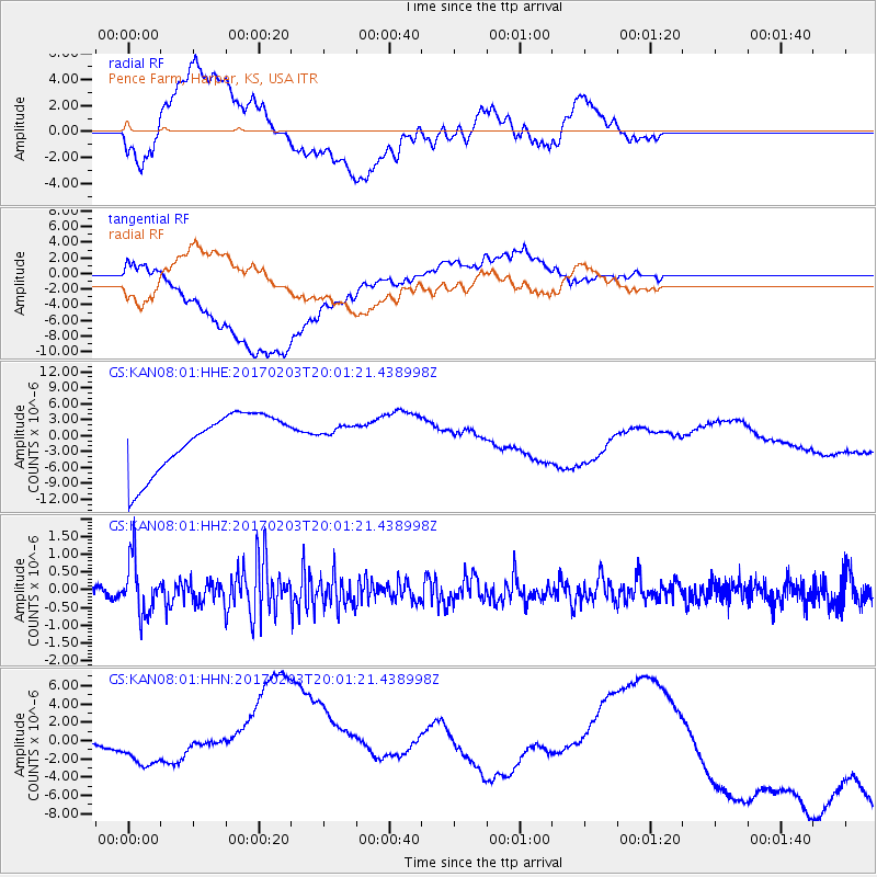
KAN08 Pence Farm, Harper, KS, USA - Earthquake Result Viewer
*The percent match for this event was below the threshold and hence no stack was calculated.
| Earthquake location: |
Leeward Islands |
| Earthquake latitude/longitude: |
15.1/-60.5 |
| Earthquake time(UTC): |
2017/02/03 (034) 19:54:21 GMT |
| Earthquake Depth: |
35 km |
| Earthquake Magnitude: |
5.6 Mwb |
| Earthquake Catalog/Contributor: |
NEIC PDE/us |
|
| Network: |
GS US Geological Survey Networks |
| Station: |
KAN08 Pence Farm, Harper, KS, USA |
| Lat/Lon: |
37.23 N/97.97 W |
| Elevation: |
375 m |
|
| Distance: |
39.8 deg |
| Az: |
310.723 deg |
| Baz: |
113.487 deg |
| Ray Param: |
$rayparam |
*The percent match for this event was below the threshold and hence was not used in the summary stack. |
|
| Radial Match: |
17.127693 % |
| Radial Bump: |
400 |
| Transverse Match: |
38.96778 % |
| Transverse Bump: |
400 |
| SOD ConfigId: |
1943534 |
| Insert Time: |
2017-02-17 19:58:25.032 +0000 |
| GWidth: |
2.5 |
| Max Bumps: |
400 |
| Tol: |
0.001 |
|
Signal To Noise
| Channel | StoN | STA | LTA |
| GS:KAN08:01:HHZ:20170203T20:01:21.438998Z | 4.593392 | 7.689502E-7 | 1.6740357E-7 |
| GS:KAN08:01:HHN:20170203T20:01:21.438998Z | 1.1692963 | 6.695691E-6 | 5.7262573E-6 |
| GS:KAN08:01:HHE:20170203T20:01:21.438998Z | 0.38383606 | 2.0923615E-6 | 5.4511847E-6 |
| Arrivals |
| Ps | |
| PpPs | |
| PsPs/PpSs | |


