You are here: Home > Network List > TS - TERRAscope (Southern California Seismic Network) Stations List
> Station NEE Needles, California, USA > Earthquake Result Viewer
NEE Needles, California, USA - Earthquake Result Viewer

| Earthquake location: |
Vanuatu Islands |
| Earthquake latitude/longitude: |
-19.5/169.2 |
| Earthquake time(UTC): |
1995/06/29 (180) 12:24:03 GMT |
| Earthquake Depth: |
144 km |
| Earthquake Magnitude: |
6.2 MB, 6.7 UNKNOWN, 6.6 MW |
| Earthquake Catalog/Contributor: |
WHDF/NEIC |
|
| Network: |
TS TERRAscope (Southern California Seismic Network) |
| Station: |
NEE Needles, California, USA |
| Lat/Lon: |
34.82 N/114.60 W |
| Elevation: |
139 m |
|
| Distance: |
90.2 deg |
| Az: |
53.019 deg |
| Baz: |
246.373 deg |
| Ray Param: |
0.041663833 |
| Estimated Moho Depth: |
10.0 km |
| Estimated Crust Vp/Vs: |
1.60 |
| Assumed Crust Vp: |
6.276 km/s |
| Estimated Crust Vs: |
3.922 km/s |
| Estimated Crust Poisson's Ratio: |
0.18 |
|
| Radial Match: |
81.0595 % |
| Radial Bump: |
400 |
| Transverse Match: |
84.68026 % |
| Transverse Bump: |
400 |
| SOD ConfigId: |
6273 |
| Insert Time: |
2010-02-26 14:30:40.478 +0000 |
| GWidth: |
2.5 |
| Max Bumps: |
400 |
| Tol: |
0.001 |
|
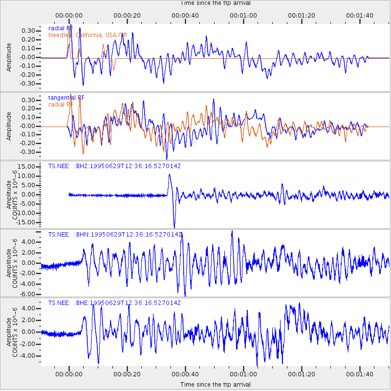
Signal To Noise
| Channel | StoN | STA | LTA |
| TS:NEE: :BHN:19950629T12:36:16.527014Z | 0.670831 | 4.1741222E-7 | 6.2223154E-7 |
| TS:NEE: :BHE:19950629T12:36:16.527014Z | 1.3954141 | 4.9792055E-7 | 3.5682635E-7 |
| TS:NEE: :BHZ:19950629T12:36:16.527014Z | 12.633338 | 3.4758928E-6 | 2.7513653E-7 |
| Arrivals |
| Ps | 1.0 SECOND |
| PpPs | 4.1 SECOND |
| PsPs/PpSs | 5.0 SECOND |


