You are here: Home > Network List > TA - USArray Transportable Network (new EarthScope stations) Stations List
> Station T12A Moapa, NV, USA > Earthquake Result Viewer
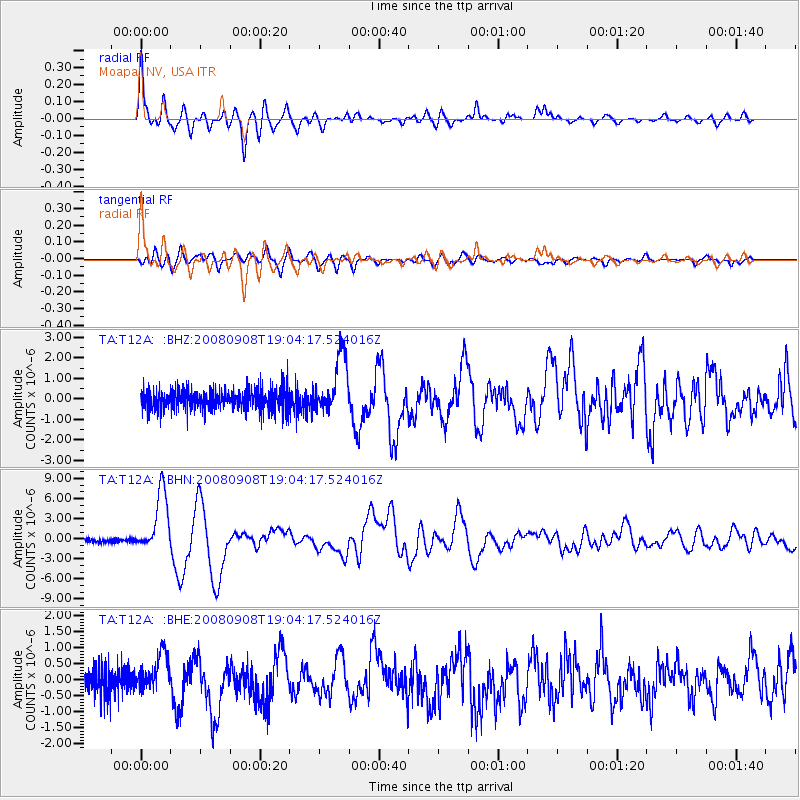
T12A Moapa, NV, USA - Earthquake Result Viewer

| Earthquake location: |
Vanuatu Islands |
| Earthquake latitude/longitude: |
-13.5/167.0 |
| Earthquake time(UTC): |
2008/09/08 (252) 18:52:06 GMT |
| Earthquake Depth: |
110 km |
| Earthquake Magnitude: |
6.4 MB, 6.9 MW, 6.9 MW |
| Earthquake Catalog/Contributor: |
WHDF/NEIC |
|
| Network: |
TA USArray Transportable Network (new EarthScope stations) |
| Station: |
T12A Moapa, NV, USA |
| Lat/Lon: |
36.73 N/114.71 W |
| Elevation: |
538 m |
|
| Distance: |
88.8 deg |
| Az: |
51.901 deg |
| Baz: |
252.32 deg |
| Ray Param: |
0.042054594 |
| Estimated Moho Depth: |
32.75 km |
| Estimated Crust Vp/Vs: |
1.69 |
| Assumed Crust Vp: |
6.276 km/s |
| Estimated Crust Vs: |
3.708 km/s |
| Estimated Crust Poisson's Ratio: |
0.23 |
|
| Radial Match: |
92.79054 % |
| Radial Bump: |
400 |
| Transverse Match: |
84.9014 % |
| Transverse Bump: |
400 |
| SOD ConfigId: |
2560 |
| Insert Time: |
2010-03-07 04:49:34.867 +0000 |
| GWidth: |
2.5 |
| Max Bumps: |
400 |
| Tol: |
0.001 |
|
Signal To Noise
| Channel | StoN | STA | LTA |
| TA:T12A: :BHN:20080908T19:04:17.524016Z | 20.101599 | 4.5205493E-6 | 2.2488504E-7 |
| TA:T12A: :BHE:20080908T19:04:17.524016Z | 1.5868365 | 5.835669E-7 | 3.6775492E-7 |
| TA:T12A: :BHZ:20080908T19:04:17.524016Z | 2.7631195 | 1.3976813E-6 | 5.058346E-7 |
| Arrivals |
| Ps | 3.7 SECOND |
| PpPs | 14 SECOND |
| PsPs/PpSs | 17 SECOND |


