You are here: Home > Network List > GS - US Geological Survey Networks Stations List
> Station OK031 2598 S. Brethren Rd., Cushing, OK, USA > Earthquake Result Viewer
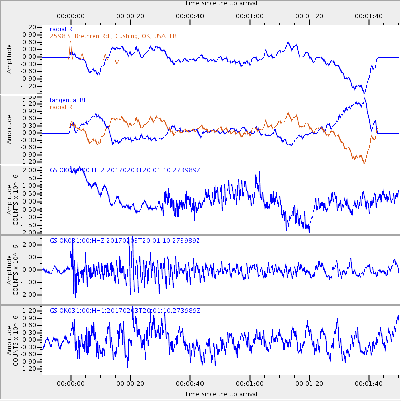
OK031 2598 S. Brethren Rd., Cushing, OK, USA - Earthquake Result Viewer
*The percent match for this event was below the threshold and hence no stack was calculated.
| Earthquake location: |
Leeward Islands |
| Earthquake latitude/longitude: |
15.1/-60.5 |
| Earthquake time(UTC): |
2017/02/03 (034) 19:54:21 GMT |
| Earthquake Depth: |
35 km |
| Earthquake Magnitude: |
5.6 Mwb |
| Earthquake Catalog/Contributor: |
NEIC PDE/us |
|
| Network: |
GS US Geological Survey Networks |
| Station: |
OK031 2598 S. Brethren Rd., Cushing, OK, USA |
| Lat/Lon: |
35.95 N/96.84 W |
| Elevation: |
290 m |
|
| Distance: |
38.5 deg |
| Az: |
309.447 deg |
| Baz: |
113.169 deg |
| Ray Param: |
$rayparam |
*The percent match for this event was below the threshold and hence was not used in the summary stack. |
|
| Radial Match: |
35.149273 % |
| Radial Bump: |
400 |
| Transverse Match: |
40.268375 % |
| Transverse Bump: |
400 |
| SOD ConfigId: |
1943534 |
| Insert Time: |
2017-02-17 19:59:27.319 +0000 |
| GWidth: |
2.5 |
| Max Bumps: |
400 |
| Tol: |
0.001 |
|
Signal To Noise
| Channel | StoN | STA | LTA |
| GS:OK031:00:HHZ:20170203T20:01:10.273989Z | 6.5439334 | 8.843411E-7 | 1.3513908E-7 |
| GS:OK031:00:HH1:20170203T20:01:10.273989Z | 1.2277039 | 4.306642E-7 | 3.507883E-7 |
| GS:OK031:00:HH2:20170203T20:01:10.273989Z | 0.8230103 | 7.3523864E-7 | 8.933529E-7 |
| Arrivals |
| Ps | |
| PpPs | |
| PsPs/PpSs | |


