You are here: Home > Network List > TA - USArray Transportable Network (new EarthScope stations) Stations List
> Station T12A Moapa, NV, USA > Earthquake Result Viewer
T12A Moapa, NV, USA - Earthquake Result Viewer
| Earthquake location: |
Volcano Islands, Japan Region |
| Earthquake latitude/longitude: |
22.0/142.7 |
| Earthquake time(UTC): |
2007/09/28 (271) 13:38:59 GMT |
| Earthquake Depth: |
276 km |
| Earthquake Magnitude: |
6.7 MB, 7.4 MW, 7.4 MW |
| Earthquake Catalog/Contributor: |
WHDF/NEIC |
|
| Network: |
TA USArray Transportable Network (new EarthScope stations) |
| Station: |
T12A Moapa, NV, USA |
| Lat/Lon: |
36.73 N/114.71 W |
| Elevation: |
538 m |
|
| Distance: |
86.6 deg |
| Az: |
51.751 deg |
| Baz: |
294.89 deg |
| Ray Param: |
0.043235585 |
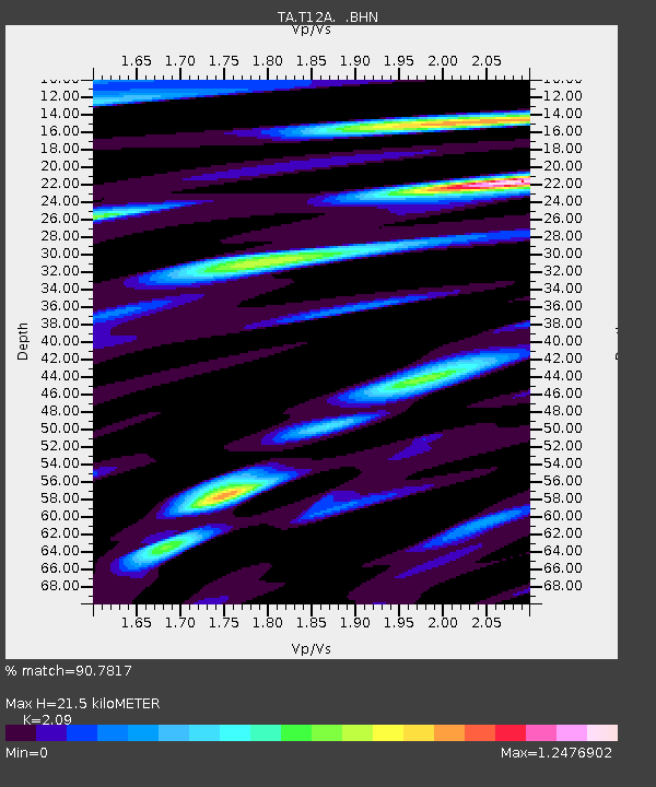
| Estimated Moho Depth: |
21.5 km |
| Estimated Crust Vp/Vs: |
2.09 |
| Assumed Crust Vp: |
6.276 km/s |
| Estimated Crust Vs: |
3.003 km/s |
| Estimated Crust Poisson's Ratio: |
0.35 |
|
| Radial Match: |
90.7817 % |
| Radial Bump: |
400 |
| Transverse Match: |
74.54037 % |
| Transverse Bump: |
400 |
| SOD ConfigId: |
2564 |
| Insert Time: |
2010-03-07 04:50:04.008 +0000 |
| GWidth: |
2.5 |
| Max Bumps: |
400 |
| Tol: |
0.001 |
|

Signal To Noise
| Channel | StoN | STA | LTA |
| TA:T12A: :BHN:20070928T13:50:40.773022Z | 12.39327 | 1.8566573E-6 | 1.4981174E-7 |
| TA:T12A: :BHE:20070928T13:50:40.773022Z | 33.786736 | 4.266673E-6 | 1.2628249E-7 |
| TA:T12A: :BHZ:20070928T13:50:40.773022Z | 101.16655 | 1.2647783E-5 | 1.2501941E-7 |
| Arrivals |
| Ps | 3.8 SECOND |
| PpPs | 10 SECOND |
| PsPs/PpSs | 14 SECOND |


