You are here: Home > Network List > TA - USArray Transportable Network (new EarthScope stations) Stations List
> Station D20K Etivluk River, AK, USA > Earthquake Result Viewer
D20K Etivluk River, AK, USA - Earthquake Result Viewer
| Earthquake location: |
Mindanao, Philippines |
| Earthquake latitude/longitude: |
5.7/126.5 |
| Earthquake time(UTC): |
2019/09/29 (272) 02:02:52 GMT |
| Earthquake Depth: |
76 km |
| Earthquake Magnitude: |
6.2 Mww |
| Earthquake Catalog/Contributor: |
NEIC PDE/us |
|
| Network: |
TA USArray Transportable Network (new EarthScope stations) |
| Station: |
D20K Etivluk River, AK, USA |
| Lat/Lon: |
68.71 N/156.61 W |
| Elevation: |
577 m |
|
| Distance: |
80.0 deg |
| Az: |
21.168 deg |
| Baz: |
259.764 deg |
| Ray Param: |
0.048447724 |
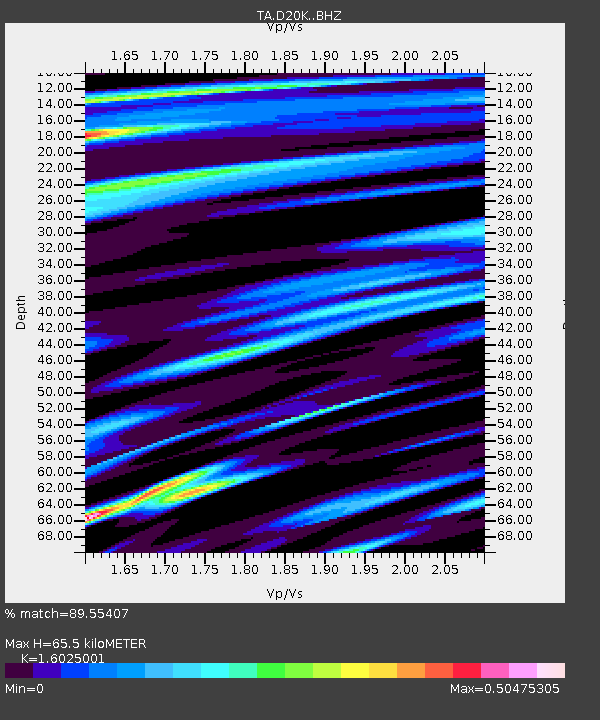
| Estimated Moho Depth: |
65.5 km |
| Estimated Crust Vp/Vs: |
1.60 |
| Assumed Crust Vp: |
6.221 km/s |
| Estimated Crust Vs: |
3.882 km/s |
| Estimated Crust Poisson's Ratio: |
0.18 |
|
| Radial Match: |
89.55407 % |
| Radial Bump: |
400 |
| Transverse Match: |
87.57369 % |
| Transverse Bump: |
400 |
| SOD ConfigId: |
19053131 |
| Insert Time: |
2019-10-13 02:10:59.624 +0000 |
| GWidth: |
2.5 |
| Max Bumps: |
400 |
| Tol: |
0.001 |
|

Signal To Noise
| Channel | StoN | STA | LTA |
| TA:D20K: :BHZ:20190929T02:14:21.874978Z | 37.333504 | 4.668442E-6 | 1.25047E-7 |
| TA:D20K: :BHN:20190929T02:14:21.874978Z | 2.2607317 | 4.2835862E-7 | 1.8947787E-7 |
| TA:D20K: :BHE:20190929T02:14:21.874978Z | 12.682003 | 1.4435547E-6 | 1.1382703E-7 |
| Arrivals |
| Ps | 6.5 SECOND |
| PpPs | 27 SECOND |
| PsPs/PpSs | 33 SECOND |


