You are here: Home > Network List > TA - USArray Transportable Network (new EarthScope stations) Stations List
> Station E17K Hotham Inlet, AK, USA > Earthquake Result Viewer
E17K Hotham Inlet, AK, USA - Earthquake Result Viewer
| Earthquake location: |
Mindanao, Philippines |
| Earthquake latitude/longitude: |
5.7/126.5 |
| Earthquake time(UTC): |
2019/09/29 (272) 02:02:52 GMT |
| Earthquake Depth: |
76 km |
| Earthquake Magnitude: |
6.2 Mww |
| Earthquake Catalog/Contributor: |
NEIC PDE/us |
|
| Network: |
TA USArray Transportable Network (new EarthScope stations) |
| Station: |
E17K Hotham Inlet, AK, USA |
| Lat/Lon: |
67.08 N/161.83 W |
| Elevation: |
233 m |
|
| Distance: |
77.7 deg |
| Az: |
22.361 deg |
| Baz: |
255.169 deg |
| Ray Param: |
0.0499975 |
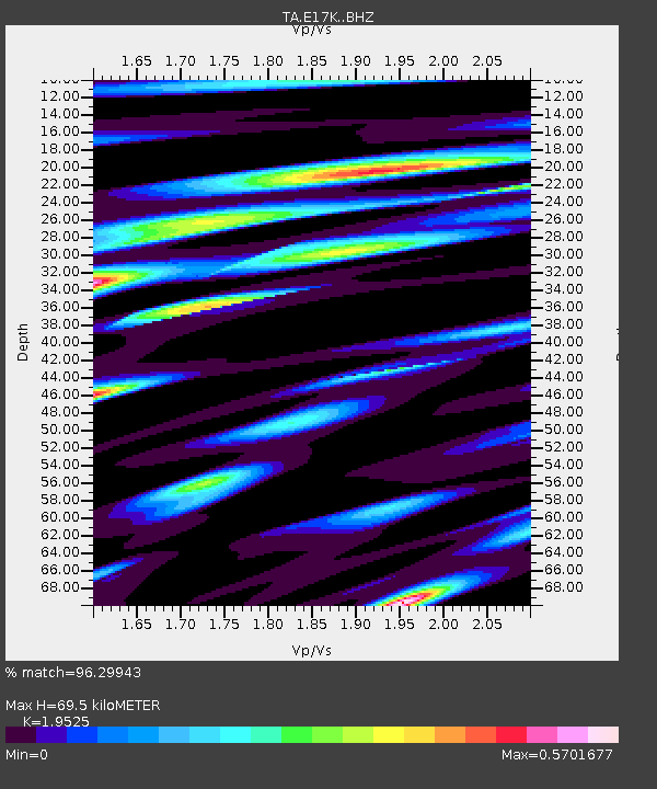
| Estimated Moho Depth: |
69.5 km |
| Estimated Crust Vp/Vs: |
1.95 |
| Assumed Crust Vp: |
6.276 km/s |
| Estimated Crust Vs: |
3.214 km/s |
| Estimated Crust Poisson's Ratio: |
0.32 |
|
| Radial Match: |
96.29943 % |
| Radial Bump: |
391 |
| Transverse Match: |
89.28502 % |
| Transverse Bump: |
400 |
| SOD ConfigId: |
19053131 |
| Insert Time: |
2019-10-13 02:11:03.596 +0000 |
| GWidth: |
2.5 |
| Max Bumps: |
400 |
| Tol: |
0.001 |
|

Signal To Noise
| Channel | StoN | STA | LTA |
| TA:E17K: :BHZ:20190929T02:14:09.425027Z | 33.756294 | 4.064577E-6 | 1.2040947E-7 |
| TA:E17K: :BHN:20190929T02:14:09.425027Z | 9.428012 | 6.95184E-7 | 7.373601E-8 |
| TA:E17K: :BHE:20190929T02:14:09.425027Z | 18.352995 | 1.6055158E-6 | 8.747977E-8 |
| Arrivals |
| Ps | 11 SECOND |
| PpPs | 32 SECOND |
| PsPs/PpSs | 43 SECOND |


