You are here: Home > Network List > IU - Global Seismograph Network (GSN - IRIS/USGS) Stations List
> Station CCM Cathedral Cave, Missouri, USA > Earthquake Result Viewer
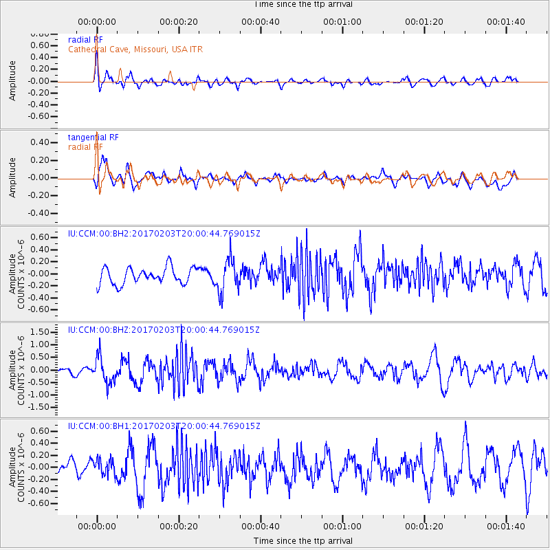
CCM Cathedral Cave, Missouri, USA - Earthquake Result Viewer
*The percent match for this event was below the threshold and hence no stack was calculated.
| Earthquake location: |
Leeward Islands |
| Earthquake latitude/longitude: |
15.1/-60.5 |
| Earthquake time(UTC): |
2017/02/03 (034) 19:54:21 GMT |
| Earthquake Depth: |
35 km |
| Earthquake Magnitude: |
5.6 Mwb |
| Earthquake Catalog/Contributor: |
NEIC PDE/us |
|
| Network: |
IU Global Seismograph Network (GSN - IRIS/USGS) |
| Station: |
CCM Cathedral Cave, Missouri, USA |
| Lat/Lon: |
38.06 N/91.24 W |
| Elevation: |
222 m |
|
| Distance: |
35.5 deg |
| Az: |
315.971 deg |
| Baz: |
121.739 deg |
| Ray Param: |
$rayparam |
*The percent match for this event was below the threshold and hence was not used in the summary stack. |
|
| Radial Match: |
69.03515 % |
| Radial Bump: |
400 |
| Transverse Match: |
73.223 % |
| Transverse Bump: |
400 |
| SOD ConfigId: |
1943534 |
| Insert Time: |
2017-02-17 20:02:54.895 +0000 |
| GWidth: |
2.5 |
| Max Bumps: |
400 |
| Tol: |
0.001 |
|
Signal To Noise
| Channel | StoN | STA | LTA |
| IU:CCM:00:BHZ:20170203T20:00:44.769015Z | 3.2500067 | 5.2665223E-7 | 1.6204652E-7 |
| IU:CCM:00:BH1:20170203T20:00:44.769015Z | 0.85072815 | 1.3714124E-7 | 1.6120455E-7 |
| IU:CCM:00:BH2:20170203T20:00:44.769015Z | 2.073743 | 2.8301938E-7 | 1.3647755E-7 |
| Arrivals |
| Ps | |
| PpPs | |
| PsPs/PpSs | |


