You are here: Home > Network List > TA - USArray Transportable Network (new EarthScope stations) Stations List
> Station I30M Mount Dempster, Yukon, CAN > Earthquake Result Viewer
I30M Mount Dempster, Yukon, CAN - Earthquake Result Viewer
| Earthquake location: |
Mindanao, Philippines |
| Earthquake latitude/longitude: |
5.7/126.5 |
| Earthquake time(UTC): |
2019/09/29 (272) 02:02:52 GMT |
| Earthquake Depth: |
76 km |
| Earthquake Magnitude: |
6.2 Mww |
| Earthquake Catalog/Contributor: |
NEIC PDE/us |
|
| Network: |
TA USArray Transportable Network (new EarthScope stations) |
| Station: |
I30M Mount Dempster, Yukon, CAN |
| Lat/Lon: |
65.22 N/136.38 W |
| Elevation: |
1399 m |
|
| Distance: |
87.8 deg |
| Az: |
24.74 deg |
| Baz: |
278.787 deg |
| Ray Param: |
0.042879123 |
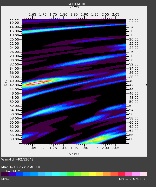
| Estimated Moho Depth: |
40.75 km |
| Estimated Crust Vp/Vs: |
1.67 |
| Assumed Crust Vp: |
6.566 km/s |
| Estimated Crust Vs: |
3.938 km/s |
| Estimated Crust Poisson's Ratio: |
0.22 |
|
| Radial Match: |
92.32648 % |
| Radial Bump: |
400 |
| Transverse Match: |
82.49837 % |
| Transverse Bump: |
400 |
| SOD ConfigId: |
19053131 |
| Insert Time: |
2019-10-13 02:11:38.966 +0000 |
| GWidth: |
2.5 |
| Max Bumps: |
400 |
| Tol: |
0.001 |
|
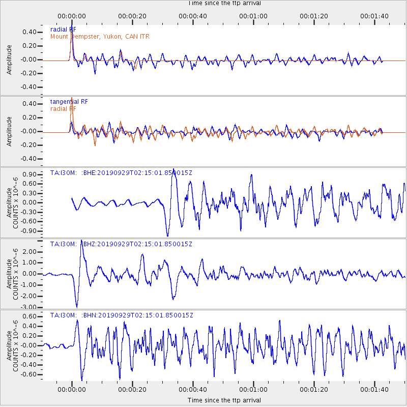
Signal To Noise
| Channel | StoN | STA | LTA |
| TA:I30M: :BHZ:20190929T02:15:01.850015Z | 27.331938 | 1.6753237E-6 | 6.129546E-8 |
| TA:I30M: :BHN:20190929T02:15:01.850015Z | 6.638817 | 3.39359E-7 | 5.1117393E-8 |
| TA:I30M: :BHE:20190929T02:15:01.850015Z | 8.688615 | 6.717291E-7 | 7.731142E-8 |
| Arrivals |
| Ps | 4.2 SECOND |
| PpPs | 16 SECOND |
| PsPs/PpSs | 20 SECOND |


