You are here: Home > Network List > TA - USArray Transportable Network (new EarthScope stations) Stations List
> Station K17K Iditarod, AK, USA > Earthquake Result Viewer
K17K Iditarod, AK, USA - Earthquake Result Viewer
| Earthquake location: |
Mindanao, Philippines |
| Earthquake latitude/longitude: |
5.7/126.5 |
| Earthquake time(UTC): |
2019/09/29 (272) 02:02:52 GMT |
| Earthquake Depth: |
76 km |
| Earthquake Magnitude: |
6.2 Mww |
| Earthquake Catalog/Contributor: |
NEIC PDE/us |
|
| Network: |
TA USArray Transportable Network (new EarthScope stations) |
| Station: |
K17K Iditarod, AK, USA |
| Lat/Lon: |
62.72 N/158.30 W |
| Elevation: |
339 m |
|
| Distance: |
78.2 deg |
| Az: |
27.071 deg |
| Baz: |
259.346 deg |
| Ray Param: |
0.04965806 |
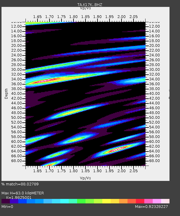
| Estimated Moho Depth: |
63.0 km |
| Estimated Crust Vp/Vs: |
1.98 |
| Assumed Crust Vp: |
6.276 km/s |
| Estimated Crust Vs: |
3.166 km/s |
| Estimated Crust Poisson's Ratio: |
0.33 |
|
| Radial Match: |
88.02789 % |
| Radial Bump: |
400 |
| Transverse Match: |
86.68986 % |
| Transverse Bump: |
400 |
| SOD ConfigId: |
19053131 |
| Insert Time: |
2019-10-13 02:11:47.340 +0000 |
| GWidth: |
2.5 |
| Max Bumps: |
400 |
| Tol: |
0.001 |
|

Signal To Noise
| Channel | StoN | STA | LTA |
| TA:K17K: :BHZ:20190929T02:14:12.19999Z | 25.41349 | 5.102745E-6 | 2.0078883E-7 |
| TA:K17K: :BHN:20190929T02:14:12.19999Z | 3.130485 | 5.4520467E-7 | 1.7415981E-7 |
| TA:K17K: :BHE:20190929T02:14:12.19999Z | 5.9662876 | 1.875394E-6 | 3.1433183E-7 |
| Arrivals |
| Ps | 10 SECOND |
| PpPs | 29 SECOND |
| PsPs/PpSs | 39 SECOND |


