You are here: Home > Network List > TA - USArray Transportable Network (new EarthScope stations) Stations List
> Station T12A Moapa, NV, USA > Earthquake Result Viewer
T12A Moapa, NV, USA - Earthquake Result Viewer
*The percent match for this event was below the threshold and hence no stack was calculated.
| Earthquake location: |
Kuril Islands |
| Earthquake latitude/longitude: |
46.7/152.5 |
| Earthquake time(UTC): |
2008/08/27 (240) 05:24:41 GMT |
| Earthquake Depth: |
65 km |
| Earthquake Magnitude: |
5.5 MB, 5.4 MW, 5.3 MW |
| Earthquake Catalog/Contributor: |
WHDF/NEIC |
|
| Network: |
TA USArray Transportable Network (new EarthScope stations) |
| Station: |
T12A Moapa, NV, USA |
| Lat/Lon: |
36.73 N/114.71 W |
| Elevation: |
538 m |
|
| Distance: |
66.1 deg |
| Az: |
61.368 deg |
| Baz: |
311.275 deg |
| Ray Param: |
$rayparam |
*The percent match for this event was below the threshold and hence was not used in the summary stack. |
|
| Radial Match: |
45.802277 % |
| Radial Bump: |
400 |
| Transverse Match: |
61.07754 % |
| Transverse Bump: |
400 |
| SOD ConfigId: |
2504 |
| Insert Time: |
2010-03-07 04:50:55.010 +0000 |
| GWidth: |
2.5 |
| Max Bumps: |
400 |
| Tol: |
0.001 |
|
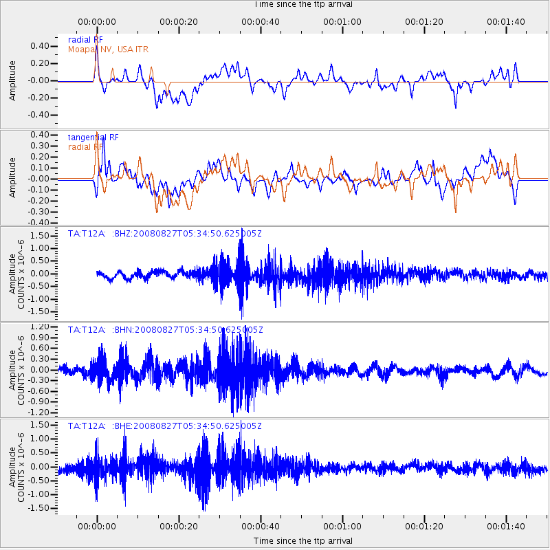
Signal To Noise
| Channel | StoN | STA | LTA |
| TA:T12A: :BHN:20080827T05:34:50.625005Z | 4.5546117 | 3.0543814E-7 | 6.7061286E-8 |
| TA:T12A: :BHE:20080827T05:34:50.625005Z | 3.1684842 | 3.9559146E-7 | 1.2485195E-7 |
| TA:T12A: :BHZ:20080827T05:34:50.625005Z | 3.5678036 | 4.7636786E-7 | 1.3351853E-7 |
| Arrivals |
| Ps | |
| PpPs | |
| PsPs/PpSs | |


