You are here: Home > Network List > TA - USArray Transportable Network (new EarthScope stations) Stations List
> Station N17K Nushagak Hills, AK, USA > Earthquake Result Viewer
N17K Nushagak Hills, AK, USA - Earthquake Result Viewer
| Earthquake location: |
Mindanao, Philippines |
| Earthquake latitude/longitude: |
5.7/126.5 |
| Earthquake time(UTC): |
2019/09/29 (272) 02:02:52 GMT |
| Earthquake Depth: |
76 km |
| Earthquake Magnitude: |
6.2 Mww |
| Earthquake Catalog/Contributor: |
NEIC PDE/us |
|
| Network: |
TA USArray Transportable Network (new EarthScope stations) |
| Station: |
N17K Nushagak Hills, AK, USA |
| Lat/Lon: |
60.53 N/157.19 W |
| Elevation: |
350 m |
|
| Distance: |
78.3 deg |
| Az: |
29.376 deg |
| Baz: |
260.794 deg |
| Ray Param: |
0.049559157 |
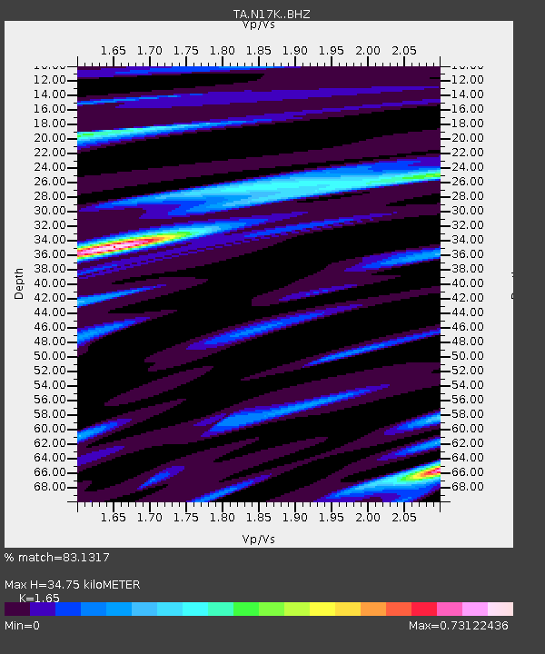
| Estimated Moho Depth: |
34.75 km |
| Estimated Crust Vp/Vs: |
1.65 |
| Assumed Crust Vp: |
6.155 km/s |
| Estimated Crust Vs: |
3.73 km/s |
| Estimated Crust Poisson's Ratio: |
0.21 |
|
| Radial Match: |
83.1317 % |
| Radial Bump: |
369 |
| Transverse Match: |
67.97516 % |
| Transverse Bump: |
400 |
| SOD ConfigId: |
19053131 |
| Insert Time: |
2019-10-13 02:12:05.612 +0000 |
| GWidth: |
2.5 |
| Max Bumps: |
400 |
| Tol: |
0.001 |
|

Signal To Noise
| Channel | StoN | STA | LTA |
| TA:N17K: :BHZ:20190929T02:14:12.999978Z | 12.320717 | 4.014369E-6 | 3.258227E-7 |
| TA:N17K: :BHN:20190929T02:14:12.999978Z | 1.6040347 | 4.3528755E-7 | 2.7137042E-7 |
| TA:N17K: :BHE:20190929T02:14:12.999978Z | 7.7871146 | 1.5068679E-6 | 1.9350786E-7 |
| Arrivals |
| Ps | 3.8 SECOND |
| PpPs | 15 SECOND |
| PsPs/PpSs | 18 SECOND |


