You are here: Home > Network List > IW - Intermountain West Stations List
> Station PLID Pearl Lake, Idaho, USA > Earthquake Result Viewer
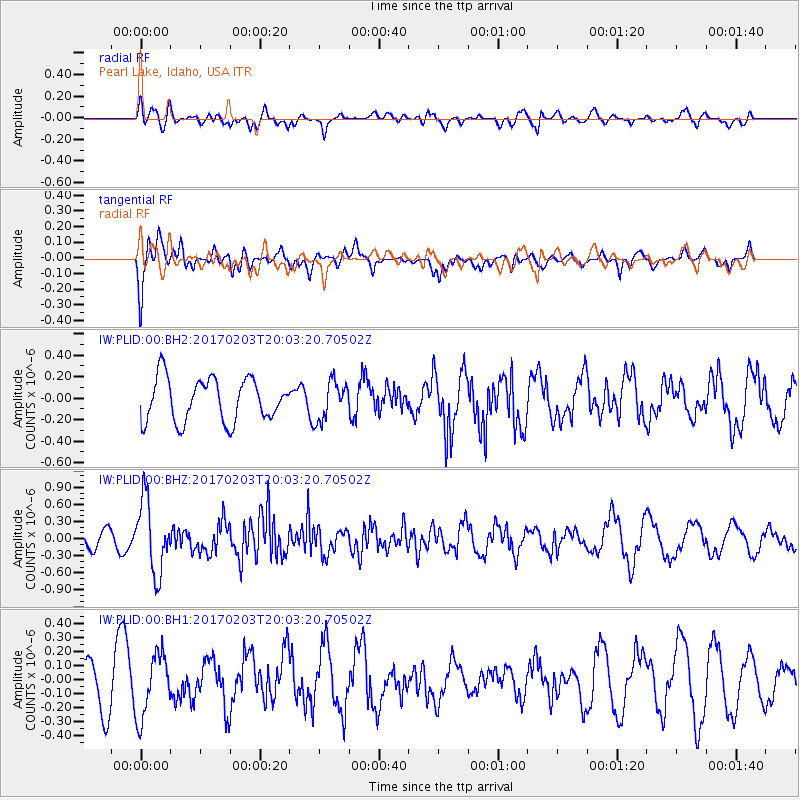
PLID Pearl Lake, Idaho, USA - Earthquake Result Viewer
*The percent match for this event was below the threshold and hence no stack was calculated.
| Earthquake location: |
Leeward Islands |
| Earthquake latitude/longitude: |
15.1/-60.5 |
| Earthquake time(UTC): |
2017/02/03 (034) 19:54:21 GMT |
| Earthquake Depth: |
35 km |
| Earthquake Magnitude: |
5.6 Mwb |
| Earthquake Catalog/Contributor: |
NEIC PDE/us |
|
| Network: |
IW Intermountain West |
| Station: |
PLID Pearl Lake, Idaho, USA |
| Lat/Lon: |
45.09 N/116.00 W |
| Elevation: |
2164 m |
|
| Distance: |
55.2 deg |
| Az: |
314.713 deg |
| Baz: |
104.302 deg |
| Ray Param: |
$rayparam |
*The percent match for this event was below the threshold and hence was not used in the summary stack. |
|
| Radial Match: |
45.85321 % |
| Radial Bump: |
400 |
| Transverse Match: |
62.52153 % |
| Transverse Bump: |
381 |
| SOD ConfigId: |
1943534 |
| Insert Time: |
2017-02-17 20:05:36.343 +0000 |
| GWidth: |
2.5 |
| Max Bumps: |
400 |
| Tol: |
0.001 |
|
Signal To Noise
| Channel | StoN | STA | LTA |
| IW:PLID:00:BHZ:20170203T20:03:20.70502Z | 2.1656294 | 6.3703703E-7 | 2.9415793E-7 |
| IW:PLID:00:BH1:20170203T20:03:20.70502Z | 0.92576164 | 2.2198915E-7 | 2.3979084E-7 |
| IW:PLID:00:BH2:20170203T20:03:20.70502Z | 0.8923073 | 1.7876893E-7 | 2.0034457E-7 |
| Arrivals |
| Ps | |
| PpPs | |
| PsPs/PpSs | |


