You are here: Home > Network List > TA - USArray Transportable Network (new EarthScope stations) Stations List
> Station T12A Moapa, NV, USA > Earthquake Result Viewer
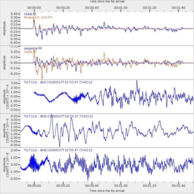
T12A Moapa, NV, USA - Earthquake Result Viewer
*The percent match for this event was below the threshold and hence no stack was calculated.
| Earthquake location: |
Near East Coast Of Honshu, Japan |
| Earthquake latitude/longitude: |
36.2/141.5 |
| Earthquake time(UTC): |
2008/05/07 (128) 16:45:20 GMT |
| Earthquake Depth: |
39 km |
| Earthquake Magnitude: |
6.1 MB, 6.7 MS, 6.8 MW, 6.8 MW |
| Earthquake Catalog/Contributor: |
WHDF/NEIC |
|
| Network: |
TA USArray Transportable Network (new EarthScope stations) |
| Station: |
T12A Moapa, NV, USA |
| Lat/Lon: |
36.73 N/114.71 W |
| Elevation: |
538 m |
|
| Distance: |
78.8 deg |
| Az: |
52.716 deg |
| Baz: |
306.733 deg |
| Ray Param: |
$rayparam |
*The percent match for this event was below the threshold and hence was not used in the summary stack. |
|
| Radial Match: |
79.885254 % |
| Radial Bump: |
400 |
| Transverse Match: |
61.444447 % |
| Transverse Bump: |
400 |
| SOD ConfigId: |
2504 |
| Insert Time: |
2010-03-07 04:51:10.077 +0000 |
| GWidth: |
2.5 |
| Max Bumps: |
400 |
| Tol: |
0.001 |
|
Signal To Noise
| Channel | StoN | STA | LTA |
| TA:T12A: :BHN:20080507T16:56:47.724021Z | 0.73502755 | 6.871086E-7 | 9.348065E-7 |
| TA:T12A: :BHE:20080507T16:56:47.724021Z | 1.0656741 | 5.345018E-7 | 5.015621E-7 |
| TA:T12A: :BHZ:20080507T16:56:47.724021Z | 0.89525574 | 5.5792367E-7 | 6.232004E-7 |
| Arrivals |
| Ps | |
| PpPs | |
| PsPs/PpSs | |


