You are here: Home > Network List > GS - US Geological Survey Networks Stations List
> Station OK029 Liberty Lake, Oklahoma, USA > Earthquake Result Viewer
OK029 Liberty Lake, Oklahoma, USA - Earthquake Result Viewer
| Earthquake location: |
Off Coast Of Central Chile |
| Earthquake latitude/longitude: |
-35.5/-73.1 |
| Earthquake time(UTC): |
2019/09/29 (272) 15:57:51 GMT |
| Earthquake Depth: |
10 km |
| Earthquake Magnitude: |
6.6 Mi |
| Earthquake Catalog/Contributor: |
NEIC PDE/at |
|
| Network: |
GS US Geological Survey Networks |
| Station: |
OK029 Liberty Lake, Oklahoma, USA |
| Lat/Lon: |
35.80 N/97.45 W |
| Elevation: |
333 m |
|
| Distance: |
74.5 deg |
| Az: |
339.638 deg |
| Baz: |
159.56 deg |
| Ray Param: |
0.052308347 |
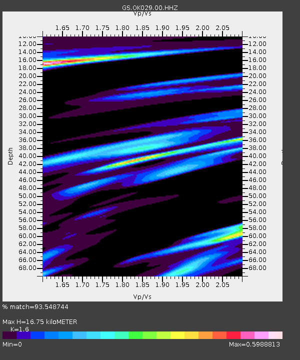
| Estimated Moho Depth: |
16.75 km |
| Estimated Crust Vp/Vs: |
1.60 |
| Assumed Crust Vp: |
6.426 km/s |
| Estimated Crust Vs: |
4.016 km/s |
| Estimated Crust Poisson's Ratio: |
0.18 |
|
| Radial Match: |
93.548744 % |
| Radial Bump: |
332 |
| Transverse Match: |
74.4727 % |
| Transverse Bump: |
400 |
| SOD ConfigId: |
19053131 |
| Insert Time: |
2019-10-13 16:05:10.809 +0000 |
| GWidth: |
2.5 |
| Max Bumps: |
400 |
| Tol: |
0.001 |
|

Signal To Noise
| Channel | StoN | STA | LTA |
| GS:OK029:00:HHZ:20190929T16:08:58.119995Z | 4.443683 | 1.2089354E-6 | 2.7205706E-7 |
| GS:OK029:00:HH1:20190929T16:08:58.119995Z | 1.5759705 | 3.7047897E-7 | 2.350799E-7 |
| GS:OK029:00:HH2:20190929T16:08:58.119995Z | 1.3986574 | 4.19861E-7 | 3.001886E-7 |
| Arrivals |
| Ps | 1.6 SECOND |
| PpPs | 6.5 SECOND |
| PsPs/PpSs | 8.2 SECOND |


