You are here: Home > Network List > LD - Lamont-Doherty Cooperative Seismographic Network Stations List
> Station GEDE Greenville, DE, USA > Earthquake Result Viewer
GEDE Greenville, DE, USA - Earthquake Result Viewer
| Earthquake location: |
Off Coast Of Central Chile |
| Earthquake latitude/longitude: |
-35.5/-73.1 |
| Earthquake time(UTC): |
2019/09/29 (272) 15:57:51 GMT |
| Earthquake Depth: |
10 km |
| Earthquake Magnitude: |
6.6 Mi |
| Earthquake Catalog/Contributor: |
NEIC PDE/at |
|
| Network: |
LD Lamont-Doherty Cooperative Seismographic Network |
| Station: |
GEDE Greenville, DE, USA |
| Lat/Lon: |
39.81 N/75.64 W |
| Elevation: |
105 m |
|
| Distance: |
75.0 deg |
| Az: |
357.978 deg |
| Baz: |
177.858 deg |
| Ray Param: |
0.051971808 |
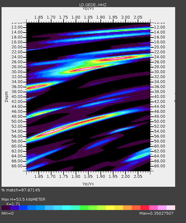
| Estimated Moho Depth: |
53.5 km |
| Estimated Crust Vp/Vs: |
1.71 |
| Assumed Crust Vp: |
6.287 km/s |
| Estimated Crust Vs: |
3.677 km/s |
| Estimated Crust Poisson's Ratio: |
0.24 |
|
| Radial Match: |
97.67145 % |
| Radial Bump: |
303 |
| Transverse Match: |
83.91472 % |
| Transverse Bump: |
400 |
| SOD ConfigId: |
19053131 |
| Insert Time: |
2019-10-13 16:05:43.427 +0000 |
| GWidth: |
2.5 |
| Max Bumps: |
400 |
| Tol: |
0.001 |
|
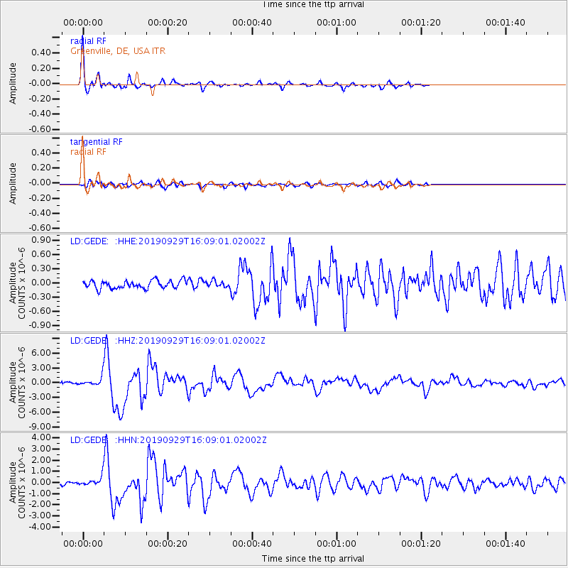
Signal To Noise
| Channel | StoN | STA | LTA |
| LD:GEDE: :HHZ:20190929T16:09:01.02002Z | 6.521952 | 8.7884547E-7 | 1.347519E-7 |
| LD:GEDE: :HHN:20190929T16:09:01.02002Z | 6.313169 | 4.1746438E-7 | 6.612596E-8 |
| LD:GEDE: :HHE:20190929T16:09:01.02002Z | 0.7881376 | 6.6057275E-8 | 8.38144E-8 |
| Arrivals |
| Ps | 6.2 SECOND |
| PpPs | 22 SECOND |
| PsPs/PpSs | 29 SECOND |


