You are here: Home > Network List > TA - USArray Transportable Network (new EarthScope stations) Stations List
> Station Q11A Duckwater, NV, USA > Earthquake Result Viewer
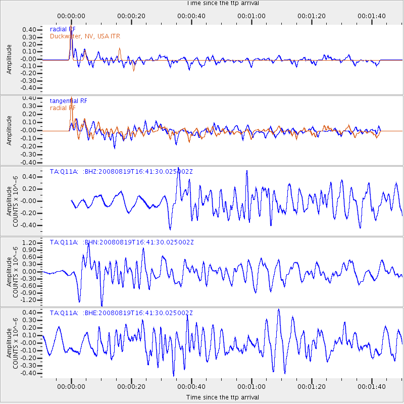
Q11A Duckwater, NV, USA - Earthquake Result Viewer

| Earthquake location: |
Tonga Islands |
| Earthquake latitude/longitude: |
-15.1/-173.5 |
| Earthquake time(UTC): |
2008/08/19 (232) 16:30:13 GMT |
| Earthquake Depth: |
8.0 km |
| Earthquake Magnitude: |
5.6 MB, 5.9 MS, 6.1 MW, 6.0 MW |
| Earthquake Catalog/Contributor: |
WHDF/NEIC |
|
| Network: |
TA USArray Transportable Network (new EarthScope stations) |
| Station: |
Q11A Duckwater, NV, USA |
| Lat/Lon: |
38.85 N/115.65 W |
| Elevation: |
1562 m |
|
| Distance: |
76.1 deg |
| Az: |
42.912 deg |
| Baz: |
237.377 deg |
| Ray Param: |
0.051221892 |
| Estimated Moho Depth: |
69.75 km |
| Estimated Crust Vp/Vs: |
1.80 |
| Assumed Crust Vp: |
6.276 km/s |
| Estimated Crust Vs: |
3.482 km/s |
| Estimated Crust Poisson's Ratio: |
0.28 |
|
| Radial Match: |
81.943146 % |
| Radial Bump: |
400 |
| Transverse Match: |
69.11608 % |
| Transverse Bump: |
400 |
| SOD ConfigId: |
2504 |
| Insert Time: |
2010-03-07 04:51:31.384 +0000 |
| GWidth: |
2.5 |
| Max Bumps: |
400 |
| Tol: |
0.001 |
|
Signal To Noise
| Channel | StoN | STA | LTA |
| TA:Q11A: :BHN:20080819T16:41:30.025002Z | 8.074955 | 5.1867266E-7 | 6.423227E-8 |
| TA:Q11A: :BHE:20080819T16:41:30.025002Z | 1.0629642 | 8.5622204E-8 | 8.055041E-8 |
| TA:Q11A: :BHZ:20080819T16:41:30.025002Z | 2.131454 | 1.781632E-7 | 8.3587636E-8 |
| Arrivals |
| Ps | 9.2 SECOND |
| PpPs | 30 SECOND |
| PsPs/PpSs | 39 SECOND |


