You are here: Home > Network List > US - United States National Seismic Network Stations List
> Station EGMT Eagleton, Montana, USA > Earthquake Result Viewer
EGMT Eagleton, Montana, USA - Earthquake Result Viewer
*The percent match for this event was below the threshold and hence no stack was calculated.
| Earthquake location: |
Leeward Islands |
| Earthquake latitude/longitude: |
15.1/-60.5 |
| Earthquake time(UTC): |
2017/02/03 (034) 19:54:21 GMT |
| Earthquake Depth: |
35 km |
| Earthquake Magnitude: |
5.6 Mwb |
| Earthquake Catalog/Contributor: |
NEIC PDE/us |
|
| Network: |
US United States National Seismic Network |
| Station: |
EGMT Eagleton, Montana, USA |
| Lat/Lon: |
48.02 N/109.75 W |
| Elevation: |
1055 m |
|
| Distance: |
52.0 deg |
| Az: |
319.837 deg |
| Baz: |
111.866 deg |
| Ray Param: |
$rayparam |
*The percent match for this event was below the threshold and hence was not used in the summary stack. |
|
| Radial Match: |
59.50943 % |
| Radial Bump: |
400 |
| Transverse Match: |
68.68902 % |
| Transverse Bump: |
400 |
| SOD ConfigId: |
1943534 |
| Insert Time: |
2017-02-17 20:11:58.484 +0000 |
| GWidth: |
2.5 |
| Max Bumps: |
400 |
| Tol: |
0.001 |
|
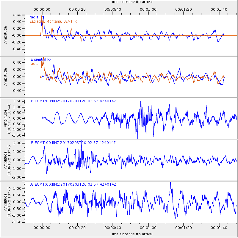
Signal To Noise
| Channel | StoN | STA | LTA |
| US:EGMT:00:BHZ:20170203T20:02:57.424014Z | 2.7797837 | 8.005837E-7 | 2.8800213E-7 |
| US:EGMT:00:BH1:20170203T20:02:57.424014Z | 1.800509 | 3.8079784E-7 | 2.1149455E-7 |
| US:EGMT:00:BH2:20170203T20:02:57.424014Z | 0.693552 | 2.147887E-7 | 3.0969372E-7 |
| Arrivals |
| Ps | |
| PpPs | |
| PsPs/PpSs | |


