You are here: Home > Network List > O2 - Oklahoma Consolidated Temporary Seismic Networks Stations List
> Station SC18 Garber, Oklahoma, USA > Earthquake Result Viewer
SC18 Garber, Oklahoma, USA - Earthquake Result Viewer
| Earthquake location: |
Off Coast Of Central Chile |
| Earthquake latitude/longitude: |
-35.5/-73.1 |
| Earthquake time(UTC): |
2019/09/29 (272) 15:57:51 GMT |
| Earthquake Depth: |
10 km |
| Earthquake Magnitude: |
6.6 Mi |
| Earthquake Catalog/Contributor: |
NEIC PDE/at |
|
| Network: |
O2 Oklahoma Consolidated Temporary Seismic Networks |
| Station: |
SC18 Garber, Oklahoma, USA |
| Lat/Lon: |
36.50 N/97.55 W |
| Elevation: |
1051 m |
|
| Distance: |
75.2 deg |
| Az: |
339.815 deg |
| Baz: |
159.548 deg |
| Ray Param: |
0.051851075 |
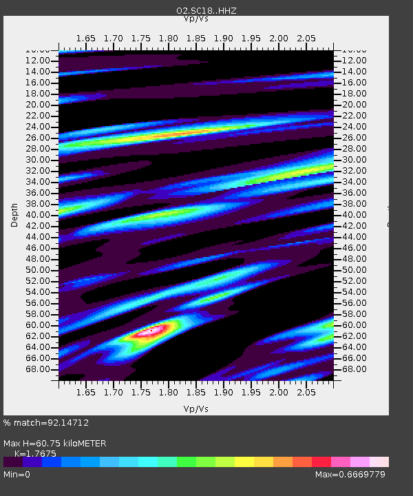
| Estimated Moho Depth: |
60.75 km |
| Estimated Crust Vp/Vs: |
1.77 |
| Assumed Crust Vp: |
6.483 km/s |
| Estimated Crust Vs: |
3.668 km/s |
| Estimated Crust Poisson's Ratio: |
0.26 |
|
| Radial Match: |
92.14712 % |
| Radial Bump: |
400 |
| Transverse Match: |
53.773884 % |
| Transverse Bump: |
400 |
| SOD ConfigId: |
19053131 |
| Insert Time: |
2019-10-13 16:07:58.729 +0000 |
| GWidth: |
2.5 |
| Max Bumps: |
400 |
| Tol: |
0.001 |
|

Signal To Noise
| Channel | StoN | STA | LTA |
| O2:SC18: :HHZ:20190929T16:09:02.085022Z | 7.27941 | 7.589266E-7 | 1.0425661E-7 |
| O2:SC18: :HHN:20190929T16:09:02.085022Z | 0.90621233 | 3.9322552E-7 | 4.3392205E-7 |
| O2:SC18: :HHE:20190929T16:09:02.085022Z | 0.32242978 | 1.6625485E-7 | 5.156312E-7 |
| Arrivals |
| Ps | 7.4 SECOND |
| PpPs | 25 SECOND |
| PsPs/PpSs | 33 SECOND |


