You are here: Home > Network List > TA - USArray Transportable Network (new EarthScope stations) Stations List
> Station Q11A Duckwater, NV, USA > Earthquake Result Viewer
Q11A Duckwater, NV, USA - Earthquake Result Viewer
| Earthquake location: |
Cuba Region |
| Earthquake latitude/longitude: |
19.4/-78.5 |
| Earthquake time(UTC): |
2007/02/04 (035) 20:56:59 GMT |
| Earthquake Depth: |
10 km |
| Earthquake Magnitude: |
5.7 MB, 5.9 MS, 6.2 MW, 6.2 MW |
| Earthquake Catalog/Contributor: |
WHDF/NEIC |
|
| Network: |
TA USArray Transportable Network (new EarthScope stations) |
| Station: |
Q11A Duckwater, NV, USA |
| Lat/Lon: |
38.85 N/115.65 W |
| Elevation: |
1562 m |
|
| Distance: |
37.5 deg |
| Az: |
309.199 deg |
| Baz: |
110.462 deg |
| Ray Param: |
0.07611902 |
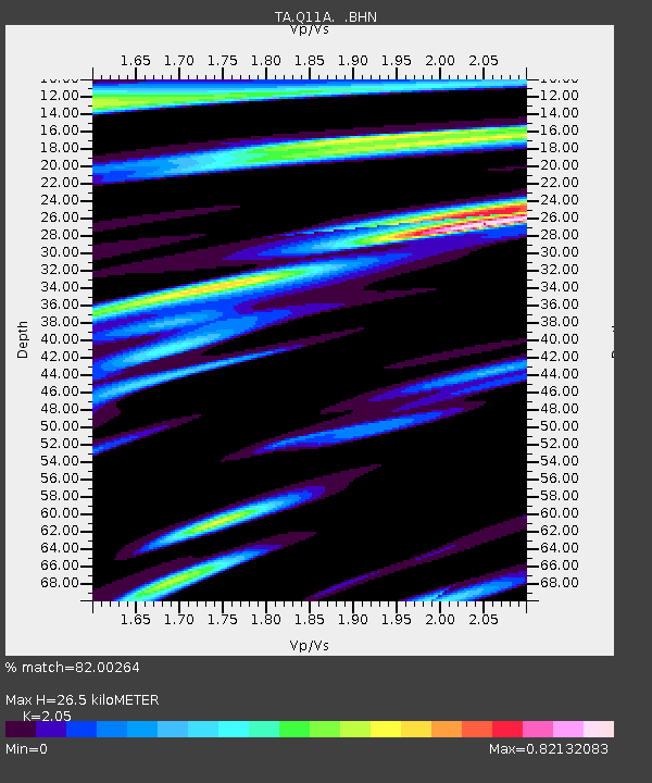
| Estimated Moho Depth: |
26.5 km |
| Estimated Crust Vp/Vs: |
2.05 |
| Assumed Crust Vp: |
6.276 km/s |
| Estimated Crust Vs: |
3.061 km/s |
| Estimated Crust Poisson's Ratio: |
0.34 |
|
| Radial Match: |
82.00264 % |
| Radial Bump: |
400 |
| Transverse Match: |
58.964306 % |
| Transverse Bump: |
400 |
| SOD ConfigId: |
2564 |
| Insert Time: |
2010-03-07 04:52:22.446 +0000 |
| GWidth: |
2.5 |
| Max Bumps: |
400 |
| Tol: |
0.001 |
|

Signal To Noise
| Channel | StoN | STA | LTA |
| TA:Q11A: :BHN:20070204T21:03:41.899012Z | 0.7123231 | 1.7961823E-7 | 2.5215834E-7 |
| TA:Q11A: :BHE:20070204T21:03:41.899012Z | 3.2019477 | 5.5776644E-7 | 1.7419597E-7 |
| TA:Q11A: :BHZ:20070204T21:03:41.899012Z | 1.6657983 | 3.5014713E-7 | 2.1019778E-7 |
| Arrivals |
| Ps | 4.7 SECOND |
| PpPs | 12 SECOND |
| PsPs/PpSs | 17 SECOND |


