You are here: Home > Network List > TA - USArray Transportable Network (new EarthScope stations) Stations List
> Station Q11A Duckwater, NV, USA > Earthquake Result Viewer
Q11A Duckwater, NV, USA - Earthquake Result Viewer
| Earthquake location: |
South Of Fiji Islands |
| Earthquake latitude/longitude: |
-25.8/179.5 |
| Earthquake time(UTC): |
2007/10/16 (289) 21:05:43 GMT |
| Earthquake Depth: |
509 km |
| Earthquake Magnitude: |
6.2 MB, 6.6 MW, 6.5 MW |
| Earthquake Catalog/Contributor: |
WHDF/NEIC |
|
| Network: |
TA USArray Transportable Network (new EarthScope stations) |
| Station: |
Q11A Duckwater, NV, USA |
| Lat/Lon: |
38.85 N/115.65 W |
| Elevation: |
1562 m |
|
| Distance: |
88.3 deg |
| Az: |
44.989 deg |
| Baz: |
234.716 deg |
| Ray Param: |
0.041690674 |
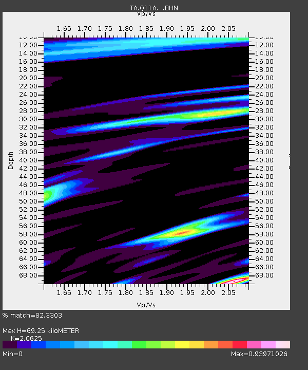
| Estimated Moho Depth: |
69.25 km |
| Estimated Crust Vp/Vs: |
2.06 |
| Assumed Crust Vp: |
6.276 km/s |
| Estimated Crust Vs: |
3.043 km/s |
| Estimated Crust Poisson's Ratio: |
0.35 |
|
| Radial Match: |
82.3303 % |
| Radial Bump: |
400 |
| Transverse Match: |
80.68454 % |
| Transverse Bump: |
400 |
| SOD ConfigId: |
2564 |
| Insert Time: |
2010-03-07 04:52:31.312 +0000 |
| GWidth: |
2.5 |
| Max Bumps: |
400 |
| Tol: |
0.001 |
|

Signal To Noise
| Channel | StoN | STA | LTA |
| TA:Q11A: :BHN:20071016T21:17:08.900005Z | 3.0814216 | 3.6913312E-7 | 1.1979311E-7 |
| TA:Q11A: :BHE:20071016T21:17:08.900005Z | 4.922415 | 8.0534204E-7 | 1.636071E-7 |
| TA:Q11A: :BHZ:20071016T21:17:08.900005Z | 18.664955 | 3.4186535E-6 | 1.8315895E-7 |
| Arrivals |
| Ps | 12 SECOND |
| PpPs | 33 SECOND |
| PsPs/PpSs | 45 SECOND |


