You are here: Home > Network List > TA - USArray Transportable Network (new EarthScope stations) Stations List
> Station Q11A Duckwater, NV, USA > Earthquake Result Viewer
Q11A Duckwater, NV, USA - Earthquake Result Viewer
| Earthquake location: |
South Of Mariana Islands |
| Earthquake latitude/longitude: |
10.5/145.7 |
| Earthquake time(UTC): |
2007/09/30 (273) 02:08:30 GMT |
| Earthquake Depth: |
14 km |
| Earthquake Magnitude: |
6.4 MB, 7.1 MS, 6.9 MW, 6.9 MW |
| Earthquake Catalog/Contributor: |
WHDF/NEIC |
|
| Network: |
TA USArray Transportable Network (new EarthScope stations) |
| Station: |
Q11A Duckwater, NV, USA |
| Lat/Lon: |
38.85 N/115.65 W |
| Elevation: |
1562 m |
|
| Distance: |
90.2 deg |
| Az: |
50.539 deg |
| Baz: |
283.471 deg |
| Ray Param: |
0.04169327 |
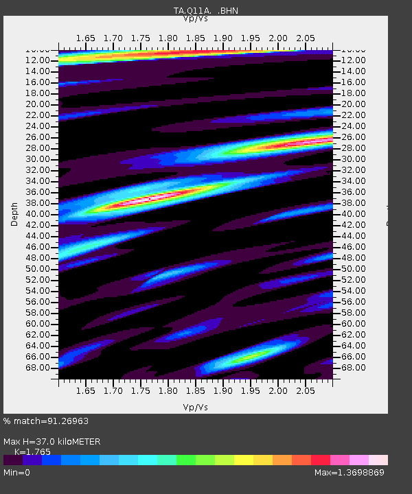
| Estimated Moho Depth: |
37.0 km |
| Estimated Crust Vp/Vs: |
1.76 |
| Assumed Crust Vp: |
6.276 km/s |
| Estimated Crust Vs: |
3.556 km/s |
| Estimated Crust Poisson's Ratio: |
0.26 |
|
| Radial Match: |
91.26963 % |
| Radial Bump: |
400 |
| Transverse Match: |
84.0171 % |
| Transverse Bump: |
400 |
| SOD ConfigId: |
2564 |
| Insert Time: |
2010-03-07 04:52:33.371 +0000 |
| GWidth: |
2.5 |
| Max Bumps: |
400 |
| Tol: |
0.001 |
|

Signal To Noise
| Channel | StoN | STA | LTA |
| TA:Q11A: :BHN:20070930T02:20:58.224016Z | 2.4520023 | 9.278274E-8 | 3.783958E-8 |
| TA:Q11A: :BHE:20070930T02:20:58.224016Z | 2.287792 | 2.1298106E-7 | 9.30946E-8 |
| TA:Q11A: :BHZ:20070930T02:20:58.224016Z | 6.8870487 | 4.6509408E-7 | 6.7531694E-8 |
| Arrivals |
| Ps | 4.6 SECOND |
| PpPs | 16 SECOND |
| PsPs/PpSs | 21 SECOND |


