You are here: Home > Network List > TA - USArray Transportable Network (new EarthScope stations) Stations List
> Station Q11A Duckwater, NV, USA > Earthquake Result Viewer
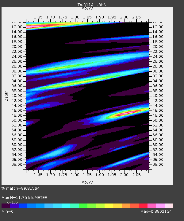
Q11A Duckwater, NV, USA - Earthquake Result Viewer
| Earthquake location: |
Off Coast Of Central Chile |
| Earthquake latitude/longitude: |
-28.7/-72.5 |
| Earthquake time(UTC): |
2006/07/16 (197) 11:42:41 GMT |
| Earthquake Depth: |
10 km |
| Earthquake Magnitude: |
5.9 MB, 5.7 MS, 6.2 MW, 6.2 MW |
| Earthquake Catalog/Contributor: |
WHDF/NEIC |
|
| Network: |
TA USArray Transportable Network (new EarthScope stations) |
| Station: |
Q11A Duckwater, NV, USA |
| Lat/Lon: |
38.85 N/115.65 W |
| Elevation: |
1562 m |
|
| Distance: |
78.3 deg |
| Az: |
326.98 deg |
| Baz: |
142.197 deg |
| Ray Param: |
0.049710736 |
| Estimated Moho Depth: |
11.75 km |
| Estimated Crust Vp/Vs: |
1.60 |
| Assumed Crust Vp: |
6.276 km/s |
| Estimated Crust Vs: |
3.922 km/s |
| Estimated Crust Poisson's Ratio: |
0.18 |
|
| Radial Match: |
89.81564 % |
| Radial Bump: |
400 |
| Transverse Match: |
84.12395 % |
| Transverse Bump: |
400 |
| SOD ConfigId: |
2665 |
| Insert Time: |
2010-03-07 04:52:55.308 +0000 |
| GWidth: |
2.5 |
| Max Bumps: |
400 |
| Tol: |
0.001 |
|

Signal To Noise
| Channel | StoN | STA | LTA |
| TA:Q11A: :BHN:20060716T11:54:10.375027Z | 2.3067229 | 2.7682017E-7 | 1.2000582E-7 |
| TA:Q11A: :BHE:20060716T11:54:10.375027Z | 3.404625 | 3.121593E-7 | 9.168684E-8 |
| TA:Q11A: :BHZ:20060716T11:54:10.375027Z | 7.4669294 | 9.569407E-7 | 1.2815718E-7 |
| Arrivals |
| Ps | 1.2 SECOND |
| PpPs | 4.7 SECOND |
| PsPs/PpSs | 5.9 SECOND |


