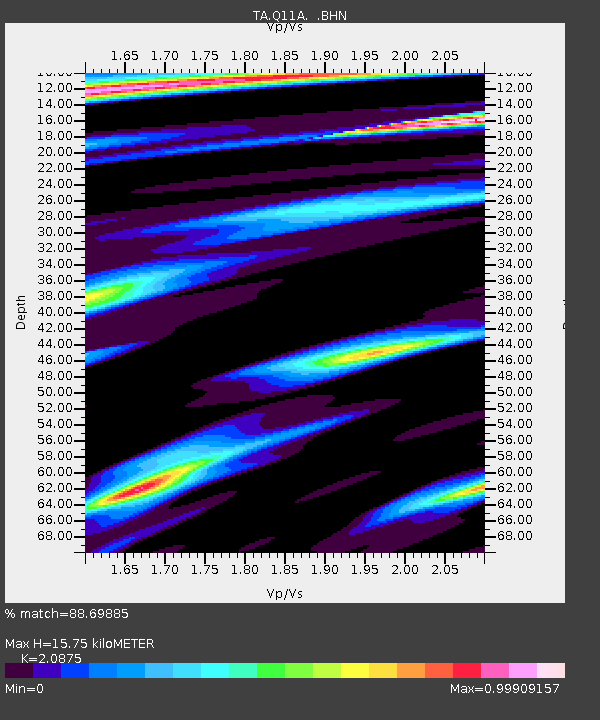
Q11A Duckwater, NV, USA - Earthquake Result Viewer

Earthquake location: Off Coast Of Chiapas, Mexico
Earthquake latitude/longitude: 15.0/-94.2
Earthquake time(UTC): 2006/06/27 (178) 13:03:12 GMT
Earthquake Depth: 29 km
Earthquake Magnitude: 5.4 MB, 5.5 MS, 5.8 MW, 5.8 MW
Earthquake Catalog/Contributor: WHDF/NEIC
Network: TA USArray Transportable Network (new EarthScope stations)
Station: Q11A Duckwater, NV, USA
Lat/Lon: 38.85 N/115.65 W
Elevation: 1562 m
Distance: 30.4 deg
Az: 325.59 deg
Baz: 135.617 deg
Ray Param: 0.07931995
Estimated Moho Depth: 15.75 km
Estimated Crust Vp/Vs: 2.09
Assumed Crust Vp: 6.276 km/s
Estimated Crust Vs: 3.006 km/s
Estimated Crust Poisson's Ratio: 0.35
Radial Match: 88.69885 %
Radial Bump: 360
Transverse Match: 71.21383 %
Transverse Bump: 400
SOD ConfigId: 2665
Insert Time: 2010-03-07 04:53:00.498 +0000
GWidth: 2.5
Max Bumps: 400
Tol: 0.001

Signal To Noise

ChannelStoNSTALTA
TA:Q11A: :BHN:20060627T13:08:51.275Z5.41218043.1618166E-75.8420383E-8
TA:Q11A: :BHE:20060627T13:08:51.275Z4.88070443.676761E-77.533259E-8
TA:Q11A: :BHZ:20060627T13:08:51.275Z14.8616888.4642966E-75.6953805E-8
Arrivals
Ps2.9 SECOND
PpPs7.3 SECOND
PsPs/PpSs10 SECOND