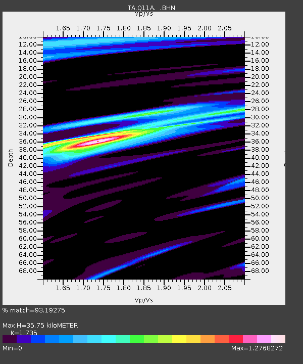
Q11A Duckwater, NV, USA - Earthquake Result Viewer
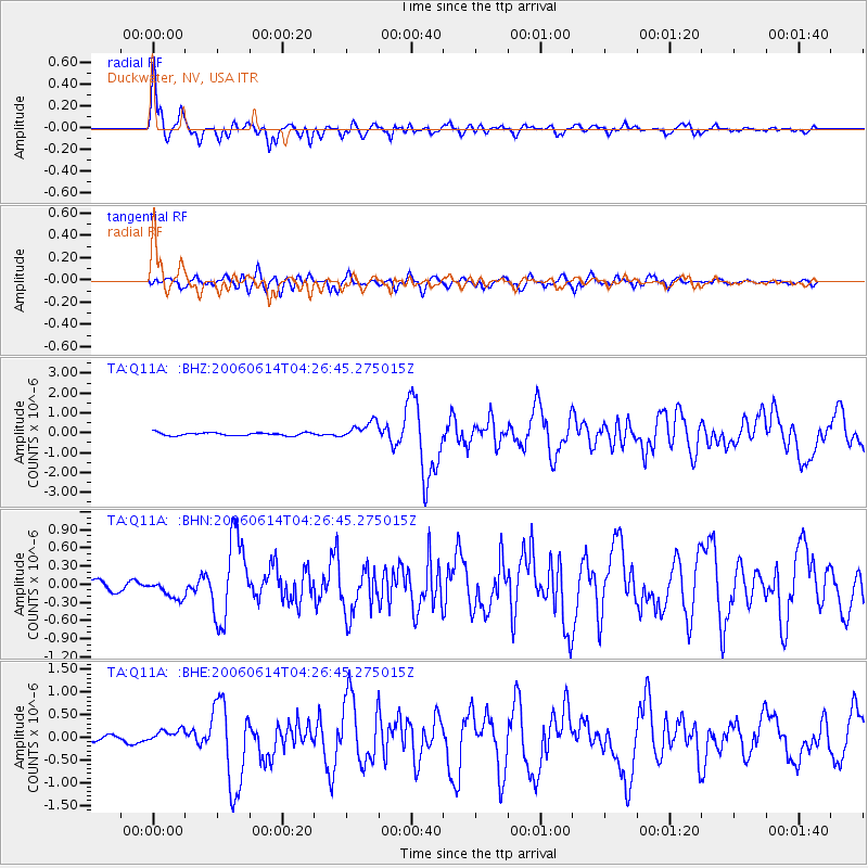
Earthquake location: Rat Islands, Aleutian Islands
Earthquake latitude/longitude: 51.8/177.1
Earthquake time(UTC): 2006/06/14 (165) 04:18:42 GMT
Earthquake Depth: 14 km
Earthquake Magnitude: 5.9 MB, 6.4 MS, 6.4 MW, 6.4 MW
Earthquake Catalog/Contributor: WHDF/NEIC
Network: TA USArray Transportable Network (new EarthScope stations)
Station: Q11A Duckwater, NV, USA
Lat/Lon: 38.85 N/115.65 W
Elevation: 1562 m
Distance: 47.4 deg
Az: 78.09 deg
Baz: 308.839 deg
Ray Param: 0.07000662
Estimated Moho Depth: 35.75 km
Estimated Crust Vp/Vs: 1.74
Assumed Crust Vp: 6.276 km/s
Estimated Crust Vs: 3.617 km/s
Estimated Crust Poisson's Ratio: 0.25
Radial Match: 93.19275 %
Radial Bump: 400
Transverse Match: 85.92814 %
Transverse Bump: 400
SOD ConfigId: 5745
Insert Time: 2010-03-07 04:53:05.146 +0000
GWidth: 2.5
Max Bumps: 400
Tol: 0.001

Signal To Noise

ChannelStoNSTALTA
TA:Q11A: :BHN:20060614T04:26:45.275015Z1.85247391.620222E-78.746261E-8
TA:Q11A: :BHE:20060614T04:26:45.275015Z1.85124461.644515E-78.883294E-8
TA:Q11A: :BHZ:20060614T04:26:45.275015Z5.87857444.3451743E-77.391544E-8
Arrivals
Ps4.4 SECOND
PpPs15 SECOND
PsPs/PpSs19 SECOND