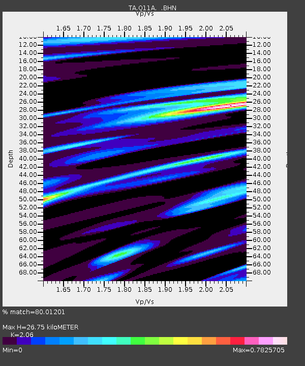
Q11A Duckwater, NV, USA - Earthquake Result Viewer

Earthquake location: Bonin Islands, Japan Region
Earthquake latitude/longitude: 26.8/142.4
Earthquake time(UTC): 2008/02/27 (058) 06:54:20 GMT
Earthquake Depth: 15 km
Earthquake Magnitude: 5.8 MB, 6.1 MS, 6.2 MW, 6.2 MW
Earthquake Catalog/Contributor: WHDF/NEIC
Network: TA USArray Transportable Network (new EarthScope stations)
Station: Q11A Duckwater, NV, USA
Lat/Lon: 38.85 N/115.65 W
Elevation: 1562 m
Distance: 82.2 deg
Az: 50.47 deg
Baz: 298.033 deg
Ray Param: 0.047066826
Estimated Moho Depth: 26.75 km
Estimated Crust Vp/Vs: 2.06
Assumed Crust Vp: 6.276 km/s
Estimated Crust Vs: 3.047 km/s
Estimated Crust Poisson's Ratio: 0.35
Radial Match: 80.01201 %
Radial Bump: 399
Transverse Match: 53.34901 %
Transverse Bump: 400
SOD ConfigId: 2564
Insert Time: 2010-03-07 04:53:09.628 +0000
GWidth: 2.5
Max Bumps: 400
Tol: 0.001

Signal To Noise

ChannelStoNSTALTA
TA:Q11A: :BHN:20080227T07:06:09.300002Z1.99519323.5872725E-71.7979573E-7
TA:Q11A: :BHE:20080227T07:06:09.300002Z1.49893832.2146007E-71.4774461E-7
TA:Q11A: :BHZ:20080227T07:06:09.300002Z1.41165943.908615E-72.7688088E-7
Arrivals
Ps4.6 SECOND
PpPs13 SECOND
PsPs/PpSs17 SECOND