You are here: Home > Network List > TA - USArray Transportable Network (new EarthScope stations) Stations List
> Station Q11A Duckwater, NV, USA > Earthquake Result Viewer
Q11A Duckwater, NV, USA - Earthquake Result Viewer
| Earthquake location: |
Near Coast Of Guatemala |
| Earthquake latitude/longitude: |
13.6/-90.6 |
| Earthquake time(UTC): |
2008/04/15 (106) 03:03:04 GMT |
| Earthquake Depth: |
33 km |
| Earthquake Magnitude: |
5.6 MB, 5.8 MS, 6.1 MW, 6.1 MW |
| Earthquake Catalog/Contributor: |
WHDF/NEIC |
|
| Network: |
TA USArray Transportable Network (new EarthScope stations) |
| Station: |
Q11A Duckwater, NV, USA |
| Lat/Lon: |
38.85 N/115.65 W |
| Elevation: |
1562 m |
|
| Distance: |
33.5 deg |
| Az: |
323.234 deg |
| Baz: |
131.808 deg |
| Ray Param: |
0.07810783 |
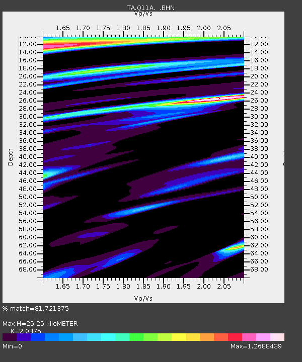
| Estimated Moho Depth: |
25.25 km |
| Estimated Crust Vp/Vs: |
2.04 |
| Assumed Crust Vp: |
6.276 km/s |
| Estimated Crust Vs: |
3.08 km/s |
| Estimated Crust Poisson's Ratio: |
0.34 |
|
| Radial Match: |
81.721375 % |
| Radial Bump: |
400 |
| Transverse Match: |
63.516987 % |
| Transverse Bump: |
400 |
| SOD ConfigId: |
2504 |
| Insert Time: |
2010-03-07 04:53:11.385 +0000 |
| GWidth: |
2.5 |
| Max Bumps: |
400 |
| Tol: |
0.001 |
|

Signal To Noise
| Channel | StoN | STA | LTA |
| TA:Q11A: :BHN:20080415T03:09:10.975002Z | 7.1648993 | 1.0776905E-6 | 1.504125E-7 |
| TA:Q11A: :BHE:20080415T03:09:10.975002Z | 3.7555573 | 5.0965934E-7 | 1.3570804E-7 |
| TA:Q11A: :BHZ:20080415T03:09:10.975002Z | 2.3856413 | 4.242947E-7 | 1.7785352E-7 |
| Arrivals |
| Ps | 4.5 SECOND |
| PpPs | 11 SECOND |
| PsPs/PpSs | 16 SECOND |


