You are here: Home > Network List > WY - Yellowstone Wyoming Seismic Network Stations List
> Station YHR Hawk's Rest, WY, USA > Earthquake Result Viewer
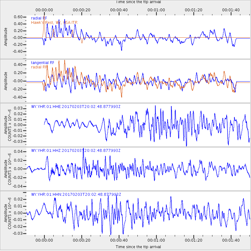
YHR Hawk's Rest, WY, USA - Earthquake Result Viewer
*The percent match for this event was below the threshold and hence no stack was calculated.
| Earthquake location: |
Leeward Islands |
| Earthquake latitude/longitude: |
15.1/-60.5 |
| Earthquake time(UTC): |
2017/02/03 (034) 19:54:21 GMT |
| Earthquake Depth: |
35 km |
| Earthquake Magnitude: |
5.6 Mwb |
| Earthquake Catalog/Contributor: |
NEIC PDE/us |
|
| Network: |
WY Yellowstone Wyoming Seismic Network |
| Station: |
YHR Hawk's Rest, WY, USA |
| Lat/Lon: |
44.11 N/110.08 W |
| Elevation: |
2976 m |
|
| Distance: |
50.9 deg |
| Az: |
315.036 deg |
| Baz: |
108.639 deg |
| Ray Param: |
$rayparam |
*The percent match for this event was below the threshold and hence was not used in the summary stack. |
|
| Radial Match: |
52.498093 % |
| Radial Bump: |
400 |
| Transverse Match: |
58.923843 % |
| Transverse Bump: |
400 |
| SOD ConfigId: |
1943534 |
| Insert Time: |
2017-02-17 20:19:53.739 +0000 |
| GWidth: |
2.5 |
| Max Bumps: |
400 |
| Tol: |
0.001 |
|
Signal To Noise
| Channel | StoN | STA | LTA |
| WY:YHR:01:HHZ:20170203T20:02:48.877993Z | 2.6586611 | 1.4714184E-8 | 5.5344334E-9 |
| WY:YHR:01:HHN:20170203T20:02:48.877993Z | 1.3524046 | 8.895784E-9 | 6.5777535E-9 |
| WY:YHR:01:HHE:20170203T20:02:48.877993Z | 2.6826618 | 1.4141481E-8 | 5.2714366E-9 |
| Arrivals |
| Ps | |
| PpPs | |
| PsPs/PpSs | |


