You are here: Home > Network List > TA - USArray Transportable Network (new EarthScope stations) Stations List
> Station 326A Caldwell Ranch, Toyah, TX, USA > Earthquake Result Viewer
326A Caldwell Ranch, Toyah, TX, USA - Earthquake Result Viewer

| Earthquake location: |
Eastern Honshu, Japan |
| Earthquake latitude/longitude: |
39.8/141.5 |
| Earthquake time(UTC): |
2008/07/23 (205) 15:26:19 GMT |
| Earthquake Depth: |
108 km |
| Earthquake Magnitude: |
6.6 MB, 6.8 MW, 6.8 MW |
| Earthquake Catalog/Contributor: |
WHDF/NEIC |
|
| Network: |
TA USArray Transportable Network (new EarthScope stations) |
| Station: |
326A Caldwell Ranch, Toyah, TX, USA |
| Lat/Lon: |
31.32 N/103.98 W |
| Elevation: |
982 m |
|
| Distance: |
86.8 deg |
| Az: |
51.229 deg |
| Baz: |
315.43 deg |
| Ray Param: |
0.0435541 |
| Estimated Moho Depth: |
18.0 km |
| Estimated Crust Vp/Vs: |
1.84 |
| Assumed Crust Vp: |
6.121 km/s |
| Estimated Crust Vs: |
3.322 km/s |
| Estimated Crust Poisson's Ratio: |
0.29 |
|
| Radial Match: |
93.80385 % |
| Radial Bump: |
400 |
| Transverse Match: |
87.09732 % |
| Transverse Bump: |
400 |
| SOD ConfigId: |
2504 |
| Insert Time: |
2010-03-07 04:54:07.508 +0000 |
| GWidth: |
2.5 |
| Max Bumps: |
400 |
| Tol: |
0.001 |
|
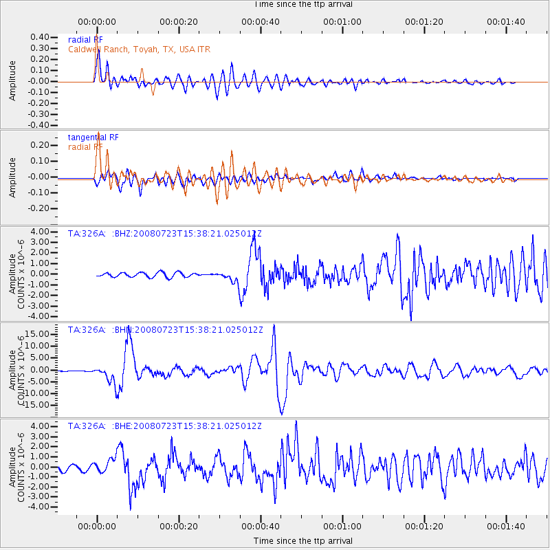
Signal To Noise
| Channel | StoN | STA | LTA |
| TA:326A: :BHN:20080723T15:38:21.025012Z | 17.9536 | 3.808508E-6 | 2.1213062E-7 |
| TA:326A: :BHE:20080723T15:38:21.025012Z | 3.3042047 | 7.062944E-7 | 2.1375624E-7 |
| TA:326A: :BHZ:20080723T15:38:21.025012Z | 2.6186945 | 5.646557E-7 | 2.156249E-7 |
| Arrivals |
| Ps | 2.5 SECOND |
| PpPs | 8.2 SECOND |
| PsPs/PpSs | 11 SECOND |


