You are here: Home > Network List > TA - USArray Transportable Network (new EarthScope stations) Stations List
> Station 326A Caldwell Ranch, Toyah, TX, USA > Earthquake Result Viewer
326A Caldwell Ranch, Toyah, TX, USA - Earthquake Result Viewer

| Earthquake location: |
North Of Svalbard |
| Earthquake latitude/longitude: |
80.3/-1.9 |
| Earthquake time(UTC): |
2009/03/06 (065) 10:50:29 GMT |
| Earthquake Depth: |
9.0 km |
| Earthquake Magnitude: |
6.6 MB, 6.5 MS, 6.5 MW, 6.4 MW |
| Earthquake Catalog/Contributor: |
WHDF/NEIC |
|
| Network: |
TA USArray Transportable Network (new EarthScope stations) |
| Station: |
326A Caldwell Ranch, Toyah, TX, USA |
| Lat/Lon: |
31.32 N/103.98 W |
| Elevation: |
982 m |
|
| Distance: |
61.4 deg |
| Az: |
287.553 deg |
| Baz: |
10.863 deg |
| Ray Param: |
0.060926985 |
| Estimated Moho Depth: |
13.75 km |
| Estimated Crust Vp/Vs: |
2.07 |
| Assumed Crust Vp: |
6.121 km/s |
| Estimated Crust Vs: |
2.957 km/s |
| Estimated Crust Poisson's Ratio: |
0.35 |
|
| Radial Match: |
89.59854 % |
| Radial Bump: |
400 |
| Transverse Match: |
83.39981 % |
| Transverse Bump: |
400 |
| SOD ConfigId: |
2658 |
| Insert Time: |
2010-03-07 04:54:43.814 +0000 |
| GWidth: |
2.5 |
| Max Bumps: |
400 |
| Tol: |
0.001 |
|
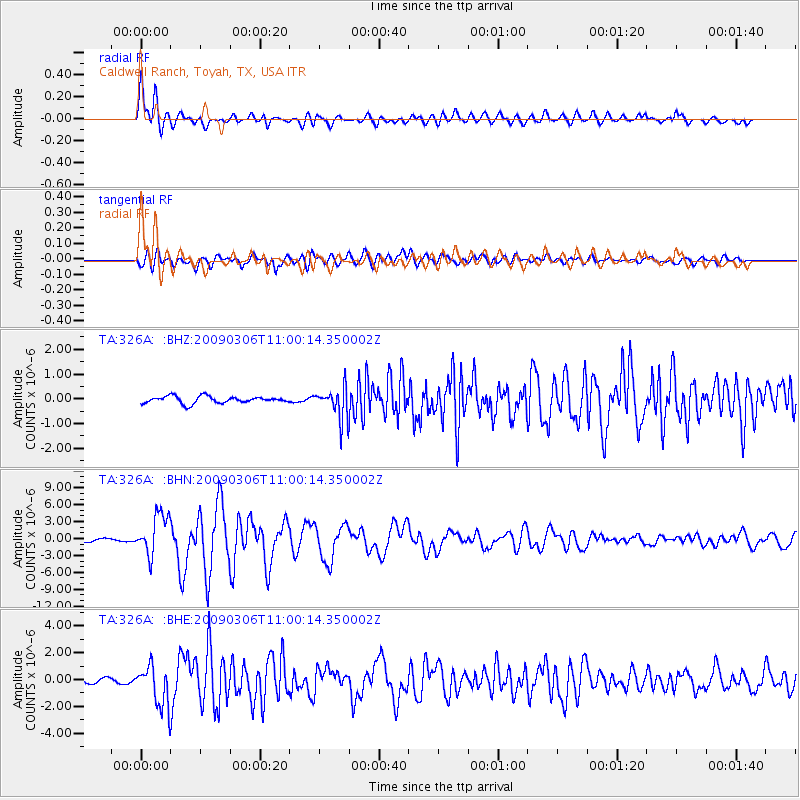
Signal To Noise
| Channel | StoN | STA | LTA |
| TA:326A: :BHN:20090306T11:00:14.350002Z | 11.027133 | 3.6121705E-6 | 3.2757114E-7 |
| TA:326A: :BHE:20090306T11:00:14.350002Z | 7.676492 | 1.5085736E-6 | 1.9651863E-7 |
| TA:326A: :BHZ:20090306T11:00:14.350002Z | 4.4913497 | 6.236711E-7 | 1.388605E-7 |
| Arrivals |
| Ps | 2.5 SECOND |
| PpPs | 6.7 SECOND |
| PsPs/PpSs | 9.1 SECOND |


