You are here: Home > Network List > TA - USArray Transportable Network (new EarthScope stations) Stations List
> Station 326A Caldwell Ranch, Toyah, TX, USA > Earthquake Result Viewer
326A Caldwell Ranch, Toyah, TX, USA - Earthquake Result Viewer

| Earthquake location: |
Kermadec Islands Region |
| Earthquake latitude/longitude: |
-31.5/-178.8 |
| Earthquake time(UTC): |
2009/05/16 (136) 00:53:52 GMT |
| Earthquake Depth: |
55 km |
| Earthquake Magnitude: |
6.1 MB, 6.5 MW, 6.3 MW |
| Earthquake Catalog/Contributor: |
WHDF/NEIC |
|
| Network: |
TA USArray Transportable Network (new EarthScope stations) |
| Station: |
326A Caldwell Ranch, Toyah, TX, USA |
| Lat/Lon: |
31.32 N/103.98 W |
| Elevation: |
982 m |
|
| Distance: |
94.5 deg |
| Az: |
55.941 deg |
| Baz: |
235.761 deg |
| Ray Param: |
0.041011926 |
| Estimated Moho Depth: |
44.25 km |
| Estimated Crust Vp/Vs: |
1.81 |
| Assumed Crust Vp: |
6.121 km/s |
| Estimated Crust Vs: |
3.386 km/s |
| Estimated Crust Poisson's Ratio: |
0.28 |
|
| Radial Match: |
84.53148 % |
| Radial Bump: |
379 |
| Transverse Match: |
67.87192 % |
| Transverse Bump: |
400 |
| SOD ConfigId: |
2760 |
| Insert Time: |
2010-03-07 04:55:00.752 +0000 |
| GWidth: |
2.5 |
| Max Bumps: |
400 |
| Tol: |
0.001 |
|
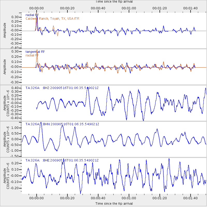
Signal To Noise
| Channel | StoN | STA | LTA |
| TA:326A: :BHN:20090516T01:06:35.549021Z | 3.9744747 | 7.378455E-7 | 1.8564604E-7 |
| TA:326A: :BHE:20090516T01:06:35.549021Z | 1.9137323 | 9.627062E-8 | 5.0305168E-8 |
| TA:326A: :BHZ:20090516T01:06:35.549021Z | 2.4595222 | 2.0359933E-7 | 8.278003E-8 |
| Arrivals |
| Ps | 5.9 SECOND |
| PpPs | 20 SECOND |
| PsPs/PpSs | 26 SECOND |


