You are here: Home > Network List > IU - Global Seismograph Network (GSN - IRIS/USGS) Stations List
> Station PMG Port Moresby, New Guinea > Earthquake Result Viewer
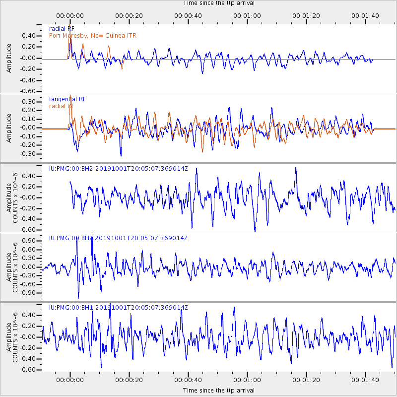
PMG Port Moresby, New Guinea - Earthquake Result Viewer
*The percent match for this event was below the threshold and hence no stack was calculated.
| Earthquake location: |
Macquarie Island Region |
| Earthquake latitude/longitude: |
-55.2/158.5 |
| Earthquake time(UTC): |
2019/10/01 (274) 19:57:10 GMT |
| Earthquake Depth: |
10 km |
| Earthquake Magnitude: |
5.4 Mww |
| Earthquake Catalog/Contributor: |
NEIC PDE/us |
|
| Network: |
IU Global Seismograph Network (GSN - IRIS/USGS) |
| Station: |
PMG Port Moresby, New Guinea |
| Lat/Lon: |
9.40 S/147.16 E |
| Elevation: |
90 m |
|
| Distance: |
46.6 deg |
| Az: |
344.543 deg |
| Baz: |
171.101 deg |
| Ray Param: |
$rayparam |
*The percent match for this event was below the threshold and hence was not used in the summary stack. |
|
| Radial Match: |
58.416386 % |
| Radial Bump: |
400 |
| Transverse Match: |
54.376133 % |
| Transverse Bump: |
400 |
| SOD ConfigId: |
19053131 |
| Insert Time: |
2019-10-15 20:02:28.716 +0000 |
| GWidth: |
2.5 |
| Max Bumps: |
400 |
| Tol: |
0.001 |
|
Signal To Noise
| Channel | StoN | STA | LTA |
| IU:PMG:00:BHZ:20191001T20:05:07.369014Z | 3.6781082 | 4.138445E-7 | 1.12515586E-7 |
| IU:PMG:00:BH1:20191001T20:05:07.369014Z | 1.2250626 | 1.4595189E-7 | 1.191383E-7 |
| IU:PMG:00:BH2:20191001T20:05:07.369014Z | 0.97378105 | 1.277876E-7 | 1.3122826E-7 |
| Arrivals |
| Ps | |
| PpPs | |
| PsPs/PpSs | |


