You are here: Home > Network List > TA - USArray Transportable Network (new EarthScope stations) Stations List
> Station Q23A Hartsel, CO, USA > Earthquake Result Viewer
Q23A Hartsel, CO, USA - Earthquake Result Viewer

| Earthquake location: |
East Of Kuril Islands |
| Earthquake latitude/longitude: |
46.9/155.2 |
| Earthquake time(UTC): |
2009/01/15 (015) 17:49:39 GMT |
| Earthquake Depth: |
36 km |
| Earthquake Magnitude: |
6.9 MB, 7.5 MS, 7.4 MW, 7.4 MW |
| Earthquake Catalog/Contributor: |
WHDF/NEIC |
|
| Network: |
TA USArray Transportable Network (new EarthScope stations) |
| Station: |
Q23A Hartsel, CO, USA |
| Lat/Lon: |
38.90 N/105.83 W |
| Elevation: |
2774 m |
|
| Distance: |
68.2 deg |
| Az: |
56.085 deg |
| Baz: |
313.122 deg |
| Ray Param: |
0.05638847 |
| Estimated Moho Depth: |
50.5 km |
| Estimated Crust Vp/Vs: |
1.71 |
| Assumed Crust Vp: |
6.159 km/s |
| Estimated Crust Vs: |
3.607 km/s |
| Estimated Crust Poisson's Ratio: |
0.24 |
|
| Radial Match: |
95.5621 % |
| Radial Bump: |
400 |
| Transverse Match: |
88.897964 % |
| Transverse Bump: |
400 |
| SOD ConfigId: |
2834 |
| Insert Time: |
2010-03-07 04:56:33.728 +0000 |
| GWidth: |
2.5 |
| Max Bumps: |
400 |
| Tol: |
0.001 |
|
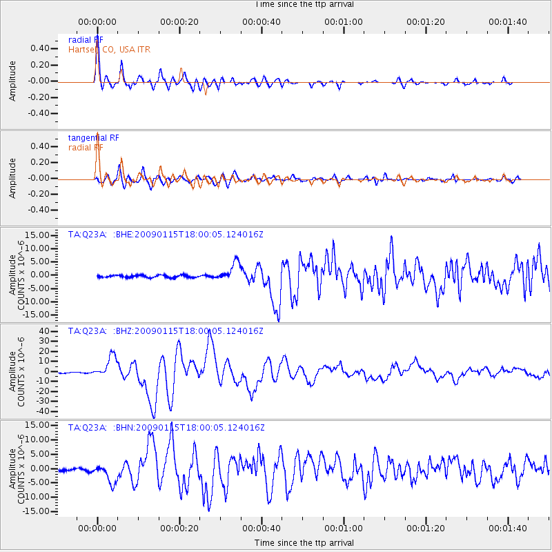
Signal To Noise
| Channel | StoN | STA | LTA |
| TA:Q23A: :BHZ:20090115T18:00:05.124016Z | 38.192867 | 1.129936E-5 | 2.9585001E-7 |
| TA:Q23A: :BHN:20090115T18:00:05.124016Z | 6.0425935 | 3.3839128E-6 | 5.6001005E-7 |
| TA:Q23A: :BHE:20090115T18:00:05.124016Z | 8.192815 | 3.5941712E-6 | 4.3869795E-7 |
| Arrivals |
| Ps | 6.0 SECOND |
| PpPs | 21 SECOND |
| PsPs/PpSs | 27 SECOND |


