You are here: Home > Network List > TA - USArray Transportable Network (new EarthScope stations) Stations List
> Station Q23A Hartsel, CO, USA > Earthquake Result Viewer
Q23A Hartsel, CO, USA - Earthquake Result Viewer
| Earthquake location: |
East Of Severnaya Zemlya |
| Earthquake latitude/longitude: |
81.6/119.5 |
| Earthquake time(UTC): |
2009/10/07 (280) 20:52:13 GMT |
| Earthquake Depth: |
8.0 km |
| Earthquake Magnitude: |
5.7 MB, 5.1 MS, 5.8 MW, 5.8 MW |
| Earthquake Catalog/Contributor: |
WHDF/NEIC |
|
| Network: |
TA USArray Transportable Network (new EarthScope stations) |
| Station: |
Q23A Hartsel, CO, USA |
| Lat/Lon: |
38.90 N/105.83 W |
| Elevation: |
2774 m |
|
| Distance: |
57.5 deg |
| Az: |
41.191 deg |
| Baz: |
352.847 deg |
| Ray Param: |
0.063475244 |
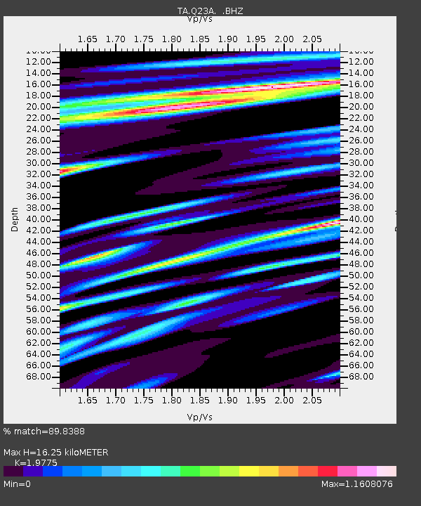
| Estimated Moho Depth: |
16.25 km |
| Estimated Crust Vp/Vs: |
1.98 |
| Assumed Crust Vp: |
6.159 km/s |
| Estimated Crust Vs: |
3.114 km/s |
| Estimated Crust Poisson's Ratio: |
0.33 |
|
| Radial Match: |
89.8388 % |
| Radial Bump: |
400 |
| Transverse Match: |
79.70401 % |
| Transverse Bump: |
400 |
| SOD ConfigId: |
2622 |
| Insert Time: |
2010-03-07 04:56:54.027 +0000 |
| GWidth: |
2.5 |
| Max Bumps: |
400 |
| Tol: |
0.001 |
|

Signal To Noise
| Channel | StoN | STA | LTA |
| TA:Q23A: :BHZ:20091007T21:01:31.324016Z | 6.539819 | 5.596776E-7 | 8.557998E-8 |
| TA:Q23A: :BHN:20091007T21:01:31.324016Z | 3.3829966 | 3.1343342E-7 | 9.264964E-8 |
| TA:Q23A: :BHE:20091007T21:01:31.324016Z | 1.099449 | 1.2598387E-7 | 1.145882E-7 |
| Arrivals |
| Ps | 2.7 SECOND |
| PpPs | 7.5 SECOND |
| PsPs/PpSs | 10 SECOND |


