You are here: Home > Network List > TA - USArray Transportable Network (new EarthScope stations) Stations List
> Station Q23A Hartsel, CO, USA > Earthquake Result Viewer
Q23A Hartsel, CO, USA - Earthquake Result Viewer
| Earthquake location: |
Andreanof Islands, Aleutian Is. |
| Earthquake latitude/longitude: |
51.5/-178.3 |
| Earthquake time(UTC): |
2009/03/30 (089) 12:11:54 GMT |
| Earthquake Depth: |
31 km |
| Earthquake Magnitude: |
6.0 MB, 5.8 MW, 5.7 MW |
| Earthquake Catalog/Contributor: |
WHDF/NEIC |
|
| Network: |
TA USArray Transportable Network (new EarthScope stations) |
| Station: |
Q23A Hartsel, CO, USA |
| Lat/Lon: |
38.90 N/105.83 W |
| Elevation: |
2774 m |
|
| Distance: |
50.5 deg |
| Az: |
74.459 deg |
| Baz: |
309.521 deg |
| Ray Param: |
0.06792775 |
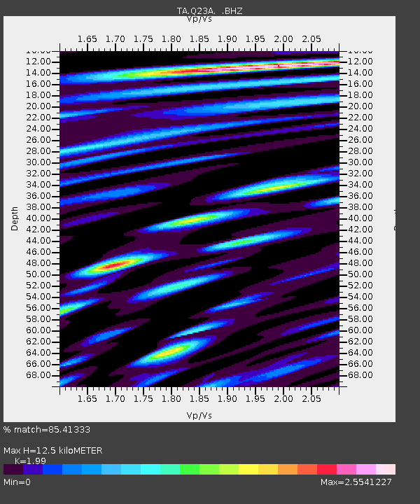
| Estimated Moho Depth: |
12.5 km |
| Estimated Crust Vp/Vs: |
1.99 |
| Assumed Crust Vp: |
6.159 km/s |
| Estimated Crust Vs: |
3.095 km/s |
| Estimated Crust Poisson's Ratio: |
0.33 |
|
| Radial Match: |
85.41333 % |
| Radial Bump: |
400 |
| Transverse Match: |
75.74154 % |
| Transverse Bump: |
400 |
| SOD ConfigId: |
2658 |
| Insert Time: |
2010-03-07 04:57:23.987 +0000 |
| GWidth: |
2.5 |
| Max Bumps: |
400 |
| Tol: |
0.001 |
|

Signal To Noise
| Channel | StoN | STA | LTA |
| TA:Q23A: :BHZ:20090330T12:20:19.775013Z | 8.164107 | 1.210685E-6 | 1.4829362E-7 |
| TA:Q23A: :BHN:20090330T12:20:19.775013Z | 2.9539213 | 5.7020253E-7 | 1.9303239E-7 |
| TA:Q23A: :BHE:20090330T12:20:19.775013Z | 4.9764433 | 9.084067E-7 | 1.8254137E-7 |
| Arrivals |
| Ps | 2.1 SECOND |
| PpPs | 5.8 SECOND |
| PsPs/PpSs | 7.9 SECOND |


