You are here: Home > Network List > TA - USArray Transportable Network (new EarthScope stations) Stations List
> Station Q23A Hartsel, CO, USA > Earthquake Result Viewer
Q23A Hartsel, CO, USA - Earthquake Result Viewer

| Earthquake location: |
Kuril Islands |
| Earthquake latitude/longitude: |
50.8/155.0 |
| Earthquake time(UTC): |
2009/04/21 (111) 05:26:11 GMT |
| Earthquake Depth: |
152 km |
| Earthquake Magnitude: |
6.0 MB, 6.2 MW, 6.2 MW |
| Earthquake Catalog/Contributor: |
WHDF/NEIC |
|
| Network: |
TA USArray Transportable Network (new EarthScope stations) |
| Station: |
Q23A Hartsel, CO, USA |
| Lat/Lon: |
38.90 N/105.83 W |
| Elevation: |
2774 m |
|
| Distance: |
66.1 deg |
| Az: |
57.399 deg |
| Baz: |
316.79 deg |
| Ray Param: |
0.057395477 |
| Estimated Moho Depth: |
12.75 km |
| Estimated Crust Vp/Vs: |
1.94 |
| Assumed Crust Vp: |
6.159 km/s |
| Estimated Crust Vs: |
3.175 km/s |
| Estimated Crust Poisson's Ratio: |
0.32 |
|
| Radial Match: |
86.15446 % |
| Radial Bump: |
400 |
| Transverse Match: |
78.284584 % |
| Transverse Bump: |
400 |
| SOD ConfigId: |
2760 |
| Insert Time: |
2010-03-07 04:57:28.502 +0000 |
| GWidth: |
2.5 |
| Max Bumps: |
400 |
| Tol: |
0.001 |
|
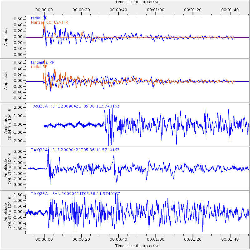
Signal To Noise
| Channel | StoN | STA | LTA |
| TA:Q23A: :BHZ:20090421T05:36:11.574016Z | 17.370523 | 1.3465432E-6 | 7.751886E-8 |
| TA:Q23A: :BHN:20090421T05:36:11.574016Z | 5.467846 | 5.8202056E-7 | 1.0644422E-7 |
| TA:Q23A: :BHE:20090421T05:36:11.574016Z | 5.5290937 | 7.6569177E-7 | 1.3848413E-7 |
| Arrivals |
| Ps | 2.0 SECOND |
| PpPs | 5.9 SECOND |
| PsPs/PpSs | 7.9 SECOND |


