You are here: Home > Network List > TA - USArray Transportable Network (new EarthScope stations) Stations List
> Station R33M Jennings River, BC, CAN > Earthquake Result Viewer
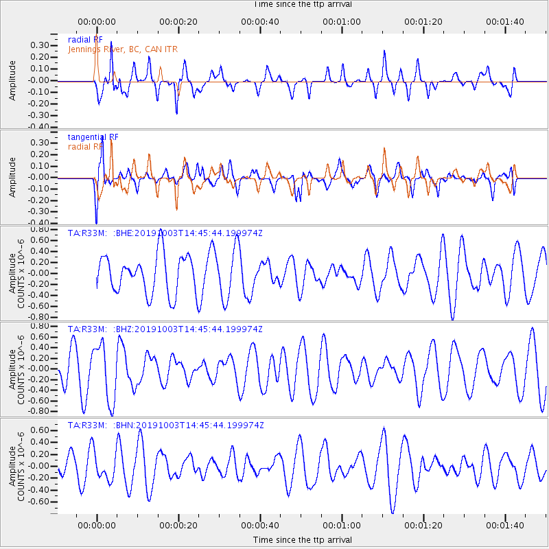
R33M Jennings River, BC, CAN - Earthquake Result Viewer
*The percent match for this event was below the threshold and hence no stack was calculated.
| Earthquake location: |
Irian Jaya, Indonesia |
| Earthquake latitude/longitude: |
-2.7/138.3 |
| Earthquake time(UTC): |
2019/10/03 (276) 14:33:09 GMT |
| Earthquake Depth: |
51 km |
| Earthquake Magnitude: |
5.5 Mww |
| Earthquake Catalog/Contributor: |
NEIC PDE/us |
|
| Network: |
TA USArray Transportable Network (new EarthScope stations) |
| Station: |
R33M Jennings River, BC, CAN |
| Lat/Lon: |
59.39 N/130.97 W |
| Elevation: |
1437 m |
|
| Distance: |
92.7 deg |
| Az: |
30.809 deg |
| Baz: |
269.234 deg |
| Ray Param: |
$rayparam |
*The percent match for this event was below the threshold and hence was not used in the summary stack. |
|
| Radial Match: |
70.69495 % |
| Radial Bump: |
353 |
| Transverse Match: |
64.95465 % |
| Transverse Bump: |
400 |
| SOD ConfigId: |
19053131 |
| Insert Time: |
2019-10-17 14:39:57.968 +0000 |
| GWidth: |
2.5 |
| Max Bumps: |
400 |
| Tol: |
0.001 |
|
Signal To Noise
| Channel | StoN | STA | LTA |
| TA:R33M: :BHZ:20191003T14:45:44.199974Z | 1.7542686 | 5.442233E-7 | 3.1022805E-7 |
| TA:R33M: :BHN:20191003T14:45:44.199974Z | 0.8550396 | 2.2058806E-7 | 2.579858E-7 |
| TA:R33M: :BHE:20191003T14:45:44.199974Z | 1.3290087 | 4.6510243E-7 | 3.4996194E-7 |
| Arrivals |
| Ps | |
| PpPs | |
| PsPs/PpSs | |


